

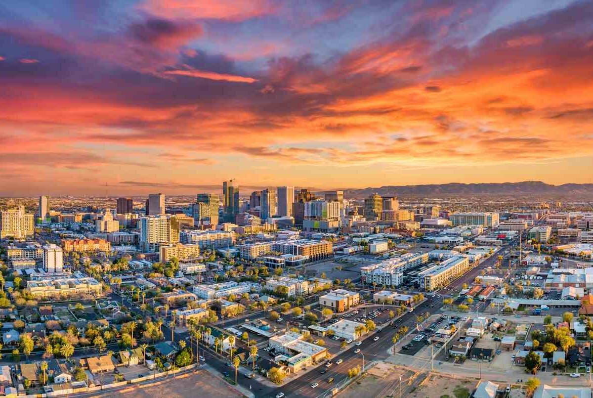
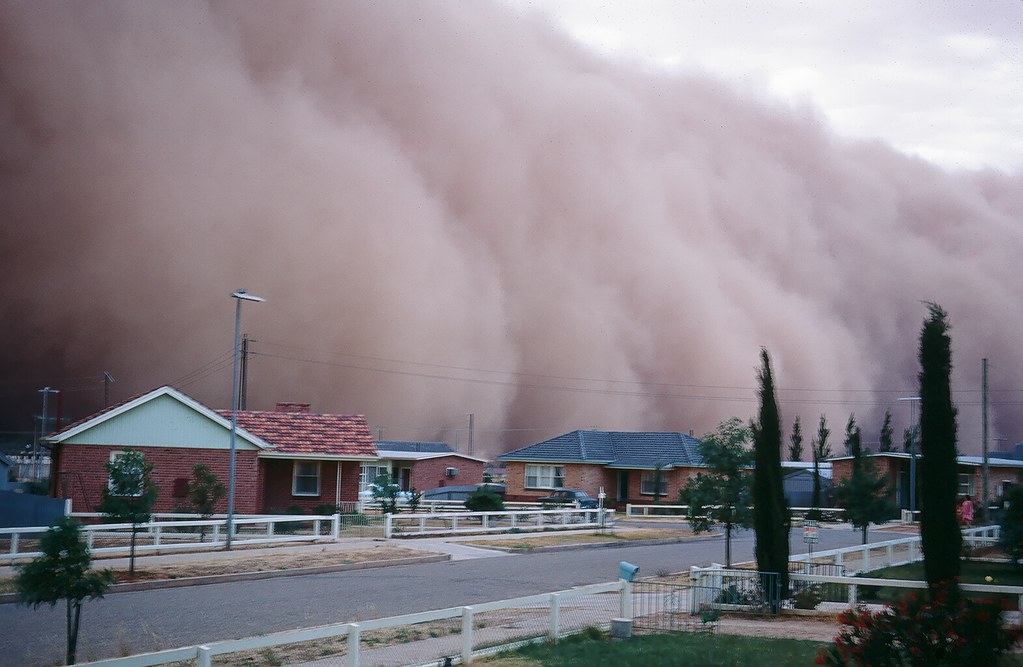
Phoenix, Arizona – A monumental wall of dust, a meteorological phenomenon known as a haboob, descended upon parts of metro Phoenix on a Monday evening in August 2025, casting the bustling urban landscape into a sudden, disorienting near-zero visibility. This extraordinary event marked the beginning of a period of widespread chaos, paralyzing transportation, disrupting critical infrastructure, and profoundly impacting the lives of tens of thousands across Maricopa County.
The scale of the storm and its immediate repercussions underscore the inherent vulnerabilities of densely populated areas to extreme weather, even in regions accustomed to monsoon season activity. What began as a visually striking, towering cloud quickly transformed into a multifaceted crisis, challenging emergency services, utility providers, and residents alike. The event garnered national attention, with media outlets describing the scenes as “apocalyptic-like” and a “towering wall of dust” that swallowed the Valley.
This in-depth report meticulously details the various facets of this powerful weather event, from its scientific origins and the moment it engulfed the city to the widespread damage, the harrowing personal accounts, and the initial, arduous efforts toward recovery. It aims to provide a comprehensive understanding of how a natural phenomenon can unleash such profound and far-reaching consequences across a major metropolitan area.

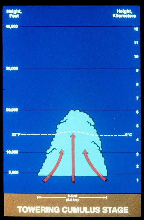
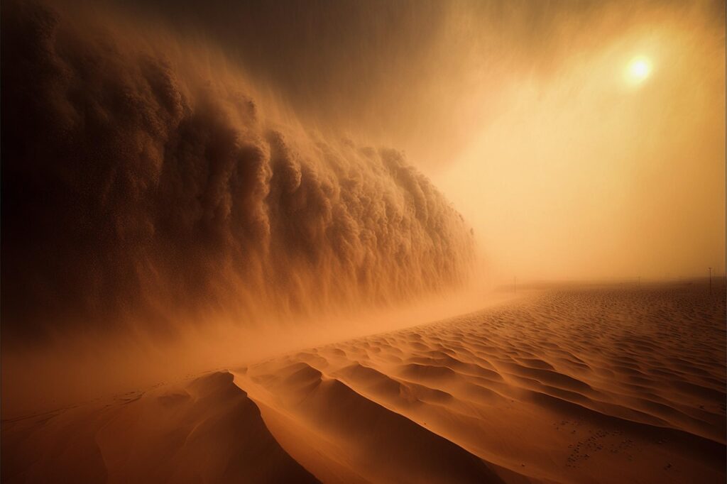
1. **The Haboob Phenomenon: Definition and Characteristics**The meteorological term “haboob,” derived from the Arabic word “haab” meaning wind or blow, refers to an incredibly strong dust and sand storm that typically traverses hot and dry regions. These formidable walls of dust are a common occurrence in arid zones worldwide, including the Sahara Desert, the Arabian Peninsula, North Africa, the Gulf of Guinea, and significantly, the Southwestern United States, particularly in states such as Arizona, New Mexico, and Texas.
Their formation is intrinsically linked to the dynamics of thunderstorms. When a traveling thunderstorm cell collapses, its powerful winds are forced downward and then blast outward, scooping up vast quantities of desert soil and debris. This action rapidly builds the dust into a colossal, rolling wall that can ascend to heights of up to 10,000 feet and stretch for miles across the landscape.
While a haboob’s wall of dust can often be observed approaching from a considerable distance, its swift progression means that by the time it reaches an observer, it is frequently too late to seek adequate shelter, especially for those operating vehicles. The worst of these storms can reduce visibility to mere feet, as the dense dust chokes out ambient light, creating an experience akin to a sudden blizzard in winter, but with fine particulates instead of snow.
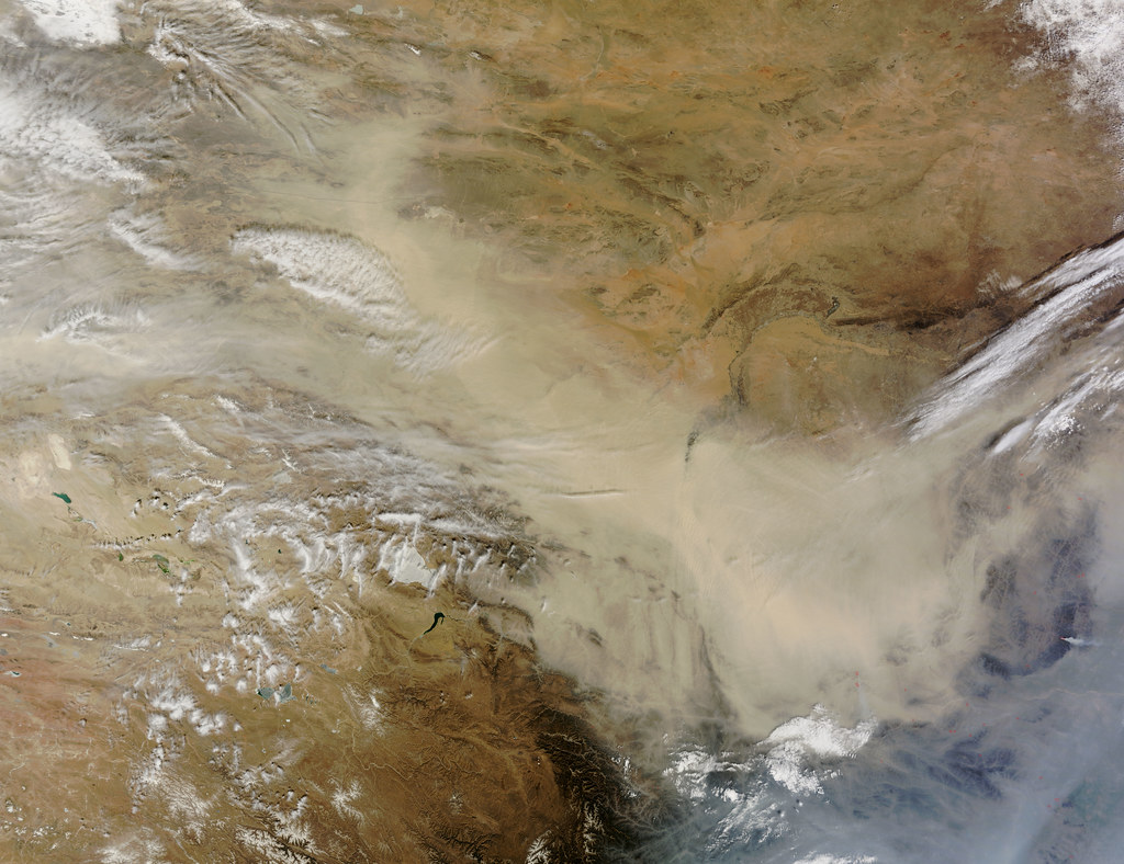
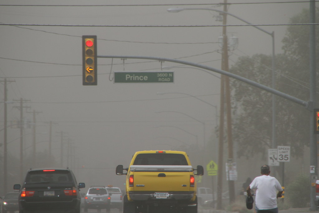
2. **Arrival and Immediate Impact: Near-Zero Visibility**On Monday evening, August 25, 2025, the Phoenix metropolitan area was directly in the path of one such immense haboob. The towering wall of dust, visibly approaching, quickly swallowed vast sections of the city, plunging them into a state of near-zero visibility within moments. This sudden atmospheric shift created profoundly dangerous conditions across the urban sprawl, transforming routine travel into a perilous endeavor.
The National Weather Service in Phoenix swiftly issued both dust storm and severe thunderstorm warnings as the system advanced into Maricopa County. These alerts explicitly cautioned drivers about the dangerously low visibility and urgently advised people to “pull aside stay alive,” emphasizing the immediate threat posed by the blinding conditions. The Arizona Department of Transportation echoed these warnings, confirming significantly reduced visibility on major arteries such as I-10 and I-17.
The dramatic darkening of the sky, described by some as an almost apocalyptic scene, caught many off guard. Workers concluding their days in downtown Phoenix were reported to have shrieked in a mixture of delight and fright as they scrambled for the sanctuary of parking structures, while winds violently whipped debris across newly wet streets. The rapid onset of the dust storm underscored its power to instantly alter the daily rhythm and safety of a major city.
3. **Subsequent Severe Weather: Thunderstorms and Wind Damage**Following closely on the heels of the suffocating dust storm, severe thunderstorms tore through Phoenix, intensifying the chaotic conditions and escalating the extent of the damage. These storms were characterized by exceptionally strong winds, with gusts recorded at up to 70 mph in certain areas, particularly at Phoenix Sky Harbor Airport.
The sheer force of these wind gusts led to immediate and visible destruction across the metropolitan area. Trees were violently torn from the ground and sent crashing down, contributing to extensive wind damage. Infrastructure was also compromised, with one notable instance involving a connector bridge at Phoenix Sky Harbor Airport that was shredded by the powerful winds, demonstrating the structural impact of the storm.
Reports from various localities detailed the tangible consequences of these accompanying thunderstorms. In Gilbert, Arizona, approximately 22 miles southeast of Phoenix, local police issued urgent advisories to residents, urging them to avoid travel due to dangerous conditions, citing pervasive “traffic light outages and downed trees across town.” These secondary impacts from the thunderstorms compounded the initial disruption caused by the haboob, extending the period of instability and risk for the populace.

4. **Widespread Power Outages: Crippling the Electrical Grid**The combined assault of the towering dust wall and the subsequent severe thunderstorms delivered a significant blow to the region’s electrical infrastructure, resulting in widespread power outages. Immediately after the storms swept through, an estimated more than 60,000 customers in Arizona found themselves without power, with the vast majority of these outages concentrated within Maricopa County.
Reports from PowerOutage.us indicated that more than 15,000 people initially lost power, primarily in Maricopa County, with Salt River Project (SRP) reporting over 41,000 customers affected and Arizona Public Service (APS) customers experiencing an additional 7,400 outages. The utility companies faced a massive challenge, with initial figures quickly rising to over 64,000 SRP customers experiencing service interruptions as the storm moved through Queek Creek, Gilbert, Phoenix, Glendale, and Peoria.
Videos circulated on social media vividly depicted entire neighborhoods plunged into darkness as the dust storm rolled through, illustrating the sudden and pervasive nature of the electrical grid failure. By the morning after the storm, while the majority of affected customers in Maricopa County had their power restored according to USA TODAY data, the sheer scale of the initial outages underscored the vulnerability of modern urban life to such powerful natural phenomena.
5. **Phoenix Sky Harbor International Airport Paralysis: Ground Stops and Damage**Phoenix Sky Harbor International Airport, a critical hub for air travel and one of the nation’s busiest airports, bore the brunt of the storm’s immediate impact. For approximately an hour, the airport was placed under a ground stop, a critical safety measure preventing any aircraft from departing or landing, as the menacing cloud of dust threatened to entirely engulf the facility. This action halted operations, causing significant cascading delays and cancellations.
Airport spokesperson Gregory E. Roybal reported that late Monday night, the airport was experiencing delays of up to 30 minutes while crews conducted initial assessments for any damage or roof leaks. These assessments later revealed more significant structural issues, with video footage sent to KPHO-TV showing damage to the roof in Terminal 4. Heather Shelbrack, the airport’s deputy aviation director for public relations, stated that crews were actively identifying leaks and working to clean up accumulated water in passenger areas.
In total, operations were severely disrupted, leading to 104 flights being delayed and three flights canceled directly at Phoenix Sky Harbor. Furthermore, 35 flights were diverted from Phoenix during the storm, exacerbating the logistical challenges. By the morning after the storm, while operations had resumed, about a dozen flights remained delayed, highlighting the lasting impact on one of the nation’s key transportation arteries.
6. **Voices from the Storm: Personal Accounts of Fear and Bravery**The human dimension of the storm was powerfully illustrated through the harrowing experiences of residents caught in its path. Bernae Boykin Hitesman was driving her 9- and 11-year-old children home from school in Arizona City, about 60 miles southeast of Phoenix, when the haboob abruptly arrived late in the afternoon. She was compelled to pull over swiftly as her car was engulfed by the storm’s dense particulate wall.
Boykin Hitesman described an experience of profound disorientation, stating, “I couldn’t see my hand in front of my face if I put my hand outside.” She recounted tasting the pervasive dust and feeling the relentless strong wind rattling her vehicle for approximately 15 minutes until the storm finally passed. Her internal struggle between fear and the need to protect her children was evident: “I was nervous,” she said. “My kids were really, really scared, so I was trying to be brave for them.”
Richard Filley, a retired university professor residing in Gilbert, also experienced the storm’s direct impact. He observed trees swaying violently and his bird feeders being knocked to the ground. Filley noted the insidious nature of the fine dust, which he said found its way through “every little crack and space” into his home. While acknowledging the destructive power, he also offered a nuanced perspective: “You look at the photos of haboobs and they are a spectacular natural phenomenon. They are kind of beautiful in their own way.”

7. **Ground-Level Devastation: Localized Damage to Homes and Infrastructure**The destructive forces of the dust storm and subsequent thunderstorms were evident across numerous communities within the Phoenix metropolitan area, leaving a trail of localized damage to both public infrastructure and private residences. In Gilbert, officials reported responding to 56 incidents of downed trees and nine reports of damaged streetlights, with the majority of these events occurring south of Williams Field Road, indicating a concentrated area of impact.
In Chandler, the damage extended to residential properties. KPHO-TV reported witnessing a large tree that had fallen directly onto a house, with the homeowner subsequently confirming roof damage. Ethan Eisner, who lives near Loop 202 and South Kyrene Road in Chandler, experienced the terrifying moment his house shook as a large tree in his front yard collapsed onto his roof during the storm. The tree penetrated the attic, shattered shingles, and even separated a concrete wall from the side of his house.
Beyond these specific incidents, anecdotal evidence and direct observation painted a picture of widespread disruption. Street signs were seen trembling from the wind, and debris was flung around streets in Phoenix. Downed branches littered sidewalks, and in the Ahwatukee Foothills area, strong winds caused a traffic sign to fall onto the road. These scattered yet pervasive instances of damage underscored the storm’s unyielding power and its capacity to inflict harm at a granular, neighborhood level.
8. **The Broader Monsoon Context: Arizona’s Enduring Weather Patterns**While the towering dust storm that engulfed Phoenix was an event of significant magnitude, it is important to situate it within the broader meteorological context of Arizona’s monsoon season. Dust storms, particularly haboobs, are not an uncommon phenomenon in this arid region, representing a recurrent, albeit often intense, aspect of the state’s summer weather patterns. This understanding underscores that while the recent event was powerful, it aligned with established climatic behaviors.
Indeed, the monsoon season itself is characterized by variability. Mark O’Malley, a meteorologist with the National Weather Service in Phoenix, described the monsoon’s nature as “very hit and miss.” He noted that while Phoenix experienced drier-than-usual conditions during this specific monsoon season, other parts of southeast and north-central Arizona had received a fair amount of rain. This regional disparity highlights the localized nature of monsoon activity, where intense events can occur even amidst broader dryness.
Despite the significant weather event, the Southwest monsoon pattern had not concluded, nor had the region’s persistent triple-digit heat. Following the initial storms on Monday, Phoenix recorded just under a quarter inch of rain. The forecast indicated a continued chance of thunderstorms into Tuesday and Wednesday, before the threat was expected to ease for the latter half of the week, with dry air subsequently limiting potential late-week thunderstorms as the heat intensified.

9. **Public Safety Directives: Advisories and Driving Precautions**The immediate aftermath of the haboob and subsequent thunderstorms necessitated swift and clear public safety advisories from meteorological and transportation authorities. As the imposing weather system advanced into Maricopa County, the National Weather Service in Phoenix promptly issued comprehensive dust storm and severe thunderstorm warnings. These alerts were critical in informing the public of the escalating dangers.
A central directive from the weather service, aimed specifically at motorists, was the urgent counsel to “pull aside stay alive.” This warning underscored the perilous conditions presented by the dangerously low visibility that quickly enveloped major roadways. The dramatic reduction in sightlines made driving exceptionally hazardous, emphasizing the need for immediate, cautious action from anyone behind the wheel.
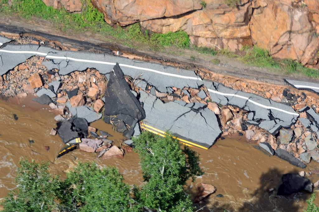
Corroborating these meteorological warnings, the Arizona Department of Transportation issued its own advisories, confirming significantly reduced visibility on key interstate arteries such as I-10 and I-17. Beyond the dust, these warnings also highlighted the presence of flooding on roadways, reinforcing the imperative for drivers to proceed with extreme caution. Local authorities, such as the police in Gilbert, Arizona, further amplified these safety messages, issuing urgent advisories to residents to avoid travel due to dangerous conditions, specifically citing pervasive traffic light outages and downed trees across town.
10. **Utility Restoration Efforts: A Massive Undertaking**The widespread power outages inflicted by the storm presented a monumental challenge for the region’s utility providers, demanding a rapid and extensive restoration effort. Immediately after the storms subsided, an estimated more than 60,000 customers across Arizona found themselves without electricity, with the vast majority of these disruptions concentrated within Maricopa County. This widespread impact underscored the vulnerability of modern infrastructure to severe weather phenomena.
Salt River Project (SRP) reported over 41,000 customers affected, with figures quickly escalating to more than 64,000 SRP customers experiencing service interruptions as the storm traversed areas including Queen Creek, Gilbert, Phoenix, Glendale, and Peoria. Jennifer Schuricht, an SRP spokesperson, noted that the utility’s system sustained “minor damage caused by vegetation blowing into power lines,” with only two poles toppled. Demonstrating remarkable efficiency, power was restored to over 45,000 SRP customers by 9:30 p.m. on the storm day, and the number of affected customers dropped below 100 by noon the following day.
Arizona Public Service (APS) also contended with significant disruptions, with nearly 18,000 customers losing electric service at the storm’s peak. Jim McDonald, an APS spokesman, attributed these outages primarily to “strong winds, lightning and trees and other vegetation falling on power lines.” The company mobilized substantial resources, deploying “more than 30 troubleshooters and eight line crews” to address diverse damage, including mangled wires, damaged transformers, and 15 toppled utility poles. Despite “difficult conditions” stemming from rain, lightning, dense vegetation, and flooding, service was restored to the vast majority of affected APS customers by 3 a.m. the next morning, highlighting the critical role of coordinated emergency response.
11. **Comprehensive Cleanup Operations Across Metro Areas: Municipal Responses**Following the immediate impacts and initial restoration efforts, municipal authorities across the Phoenix metropolitan area launched extensive cleanup operations to address the physical remnants of the storm. The scale of debris, particularly downed trees and damaged infrastructure, necessitated a concerted response to restore normalcy and ensure public safety.
In Gilbert, Arizona, city officials responded to a significant number of incidents directly attributable to the storm’s destructive forces. Reports included 56 instances of downed trees and nine reports of damaged streetlights, with a notable concentration of these events occurring south of Williams Field Road. These figures illustrate the localized yet pervasive nature of the storm’s impact on public spaces and essential services within that community.
Chandler, another heavily impacted city, saw its crews dedicated throughout the day to the arduous task of debris removal. City spokesperson Toni Smith informed The Arizona Republic that “hundreds of trees and branches that fell and need to be cleared.” These operations extended to clearing leaves and other accumulated debris from city pools, parks, streets, and crucial water-treatment plants. Similar mobilization of crews was observed in Phoenix and other areas, while Scottsdale crews identified 35 fallen trees but reported minimal other damage and no widespread flooding, indicating a comprehensive valley-wide effort to mitigate the storm’s physical aftermath.
12. **The “Arrakis from Dune” Experience: In-depth Homeowner Testimonials**The human experience of the storm transcended official reports, finding voice in personal accounts that painted vivid pictures of both fear and resilience. Ethan Eisner, residing in Chandler near Loop 202 and South Kyrene Road, recounted a terrifying moment when his house shook violently as a large tree in his front yard collapsed onto his roof. “I just felt the huge, just like vibration of the house, just like boom,” Eisner said, describing the sudden, forceful impact.
The tree’s descent caused substantial damage, penetrating the attic, shattering shingles onto the ground, and even separating a concrete wall from the side of his house. Eisner described the surreal, blinding conditions outside, stating, “It looked like pretty much like Arrakis from Dune, how it was just completely dusted out.” He further quipped that his wife joked he looked like he “just came back from Burning Man” after venturing out with goggles and a mask, emphasizing the unprecedented nature of the dusty environment.
In Ahwatukee, retirees Belva Stites and Judy Steffen shared their own experiences of the storm’s fury. Stites, who lost a Palo Verde tree, spent the following morning trimming debris. Steffen, whose backyard backs onto a golf course, lost two trees and an ocotillo in her front yard. She recounted the profound sensory impact, stating, “It felt like the whole house was vibrating from the wind,” and that “The rain hitting the window sounded like rocks.” For Steffen, a Chicago native who had lived through many haboobs since 2008, “this storm felt like the worst one,” underscoring its exceptional severity.

13. **Comparative Perspective: The Burning Man Dust Storm**The Phoenix haboob, while remarkable, was not an isolated meteorological event of its kind in the region during that period. Just days prior, a significant dust storm had impacted the annual Burning Man Festival in Black Rock City, Nevada, approximately 120 miles from Reno. This earlier event provided a compelling point of comparison for the destructive power of such natural phenomena.
As attendees began arriving at the remote desert location for the festival, strong thunderstorm winds on Saturday kicked up a substantial dust plume. This led to the closure of access roads and created immediate challenges for vendors, who scrambled to secure their temporary structures. Vendor Mike Chuda told CNN affiliate KTVN, “We had to take our sign down. We weren’t expecting that,” adding that “The wind was in such a perfect angle that it was bending our booth forward. So that was pretty wild.”
The severity of the Nevada dust storm was further highlighted by its impact on campers. Wind gusts reaching up to 50 mph toppled tents and porta-potties across the festival grounds. Organizers responded by issuing urgent warnings to those in Black Rock City, advising them to “secure your structures and belongings” amidst the intense winds and emphasizing that people should not drive if their visibility was compromised. These parallel events underscore the broad regional vulnerability to powerful dust storms during the late summer season.

14. **Media and Public Reaction: “Apocalyptic Scenes” and Community Discourse**The sheer spectacle and widespread impact of the Phoenix haboob quickly propelled it into the national spotlight, capturing the attention of both local residents and national news outlets. Media organizations described the event with evocative language, characterizing the scenes as “apocalyptic-like” and marveling at the “towering wall of dust” that appeared to swallow the entire Valley. Such portrayals underscored the dramatic and disorienting nature of the storm, which left a lasting impression.
The storm immediately became a dominant topic of community discourse, creating what was described as “next-day buzz” among residents. People eagerly compared photos of flooding and damage, reflecting a shared experience of a truly extraordinary weather event. Even those who did not suffer noticeable damage felt the storm’s surge, contributing to the collective narrative.
Commercial airline pilots Jason Heath and Jamie Gunderson, for instance, felt the storm’s powerful impact from their respective homes in the Laveen area. Gunderson noted it “started as a big wall of dust,” and while it blew around some lawn chairs at his residence, there was no significant damage in his immediate vicinity. Heath, however, was less fortunate, reporting that a tree in his yard lost branches, and his home experienced a power outage from approximately 7 p.m. to 4:30 a.m. These varied individual experiences, from awe to inconvenience and property damage, collectively shaped the public’s understanding and memory of the monumental dust storm that paralyzed Phoenix.
The towering wall of dust that descended upon Phoenix in August 2025 stands as a stark reminder of the immense power of natural forces, even in regions accustomed to extreme weather. From the initial near-zero visibility and widespread infrastructural damage to the remarkable speed of utility restoration and the vivid personal testimonials, this event illuminated the complex interplay between meteorological phenomena and urban resilience. It underscored the critical importance of early warning systems, robust emergency responses, and the enduring spirit of communities facing the unexpected. The haboob, an awe-inspiring and disruptive force, ultimately served to reinforce both the fragility of modern life and the strength of a city united in the face of environmental challenges.


