

The 2025 Atlantic hurricane season has been a dynamic canvas of meteorological events, with each named storm carving its own unique, often unpredictable, trajectory. Amidst this unfolding drama, Tropical Storm Jerry emerged as a particularly compelling narrative, capturing the attention of forecasters and residents across the Caribbean and beyond.
From its swift genesis in the central Atlantic to the rapidly evolving forecasts regarding its strength and path, Jerry embodied the complex and often fluid nature of tropical cyclone activity. It served as a stark reminder of the vigilant monitoring and sophisticated modeling required to anticipate the whims of these powerful natural phenomena.
This in-depth exploration will meticulously track Tropical Storm Jerry’s initial stages, examining its formation, the early, assertive forecasts of its potential hurricane status, and the immediate implications for the vulnerable Northern Leeward Islands. We will dissect the granular details of its projected impacts and the critical shifts in meteorological predictions that ultimately reshaped its destiny.

1. **Jerry’s Genesis: The Formation of the 10th Named Storm**Tropical Storm Jerry officially formed in the central Atlantic on Tuesday morning, becoming the 10th named storm of the 2025 Atlantic hurricane season. This designation followed closely after the National Hurricane Center (NHC) first identified the system as Invest 95L, a precursor label for disturbances under observation for potential tropical development.
Initially, Jerry was positioned approximately 1,300 miles east-southeast of the Windward Islands on the eastern end of the Caribbean Sea. It quickly began its westward movement, noted at an impressive speed of 24 mph, indicating a swift-developing and fast-moving system right from its inception.
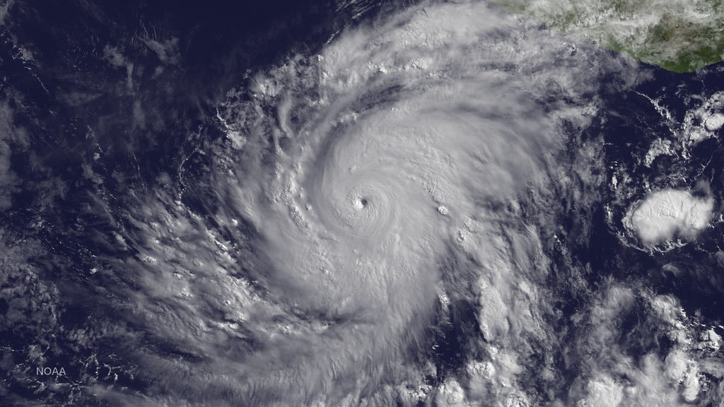
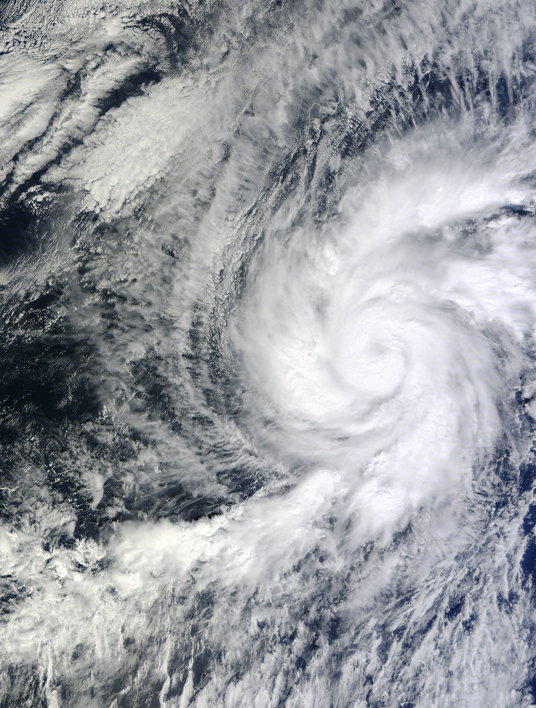
As of Tuesday afternoon, satellite imagery confirmed Jerry’s developing structure, producing maximum sustained winds of 45 mph with higher gusts. The system was clearly demonstrating signs of organization with clouds, showers, and thunderstorms beginning to wrap around its developing center, signaling its formal classification as a named storm.
By early Thursday, Jerry’s core was located about 100 miles east of the northern Leeward Islands, continuing its northwest trajectory at 17 mph. This progression established it as a significant entity within the ongoing hurricane season, demanding immediate attention from meteorological agencies and regional authorities.
The initial reports underscored the storm’s early vigor and rapid organization. Its quick formation and consistent movement westward set the stage for a period of heightened vigilance across a broad swath of the Atlantic basin, from the Lesser Antilles to potentially further afield.

2. **Early Forecasts: The Path to Hurricane Status**Upon its formation, environmental conditions appeared notably favorable for additional development and strengthening. Forecasters at the National Hurricane Center highlighted the presence of warm waters and abundant moisture, classic ingredients for tropical cyclone intensification. These factors led to initial predictions that Jerry could soon become a hurricane.
Indeed, projections indicated that Jerry could reach hurricane status by late Friday or Saturday, or even by the evening of October 8th, according to various advisories. The expectation was that steady strengthening would continue, pushing Jerry beyond the tropical storm threshold of 74 mph sustained winds.
AccuWeather Lead Hurricane Expert Alex DaSilva specifically stated, “Future Jerry is expected to strengthen into the basin’s fifth hurricane of the season in the process.” This outlook emphasized the perceived high likelihood of Jerry evolving into a formidable force as it moved across the Atlantic.
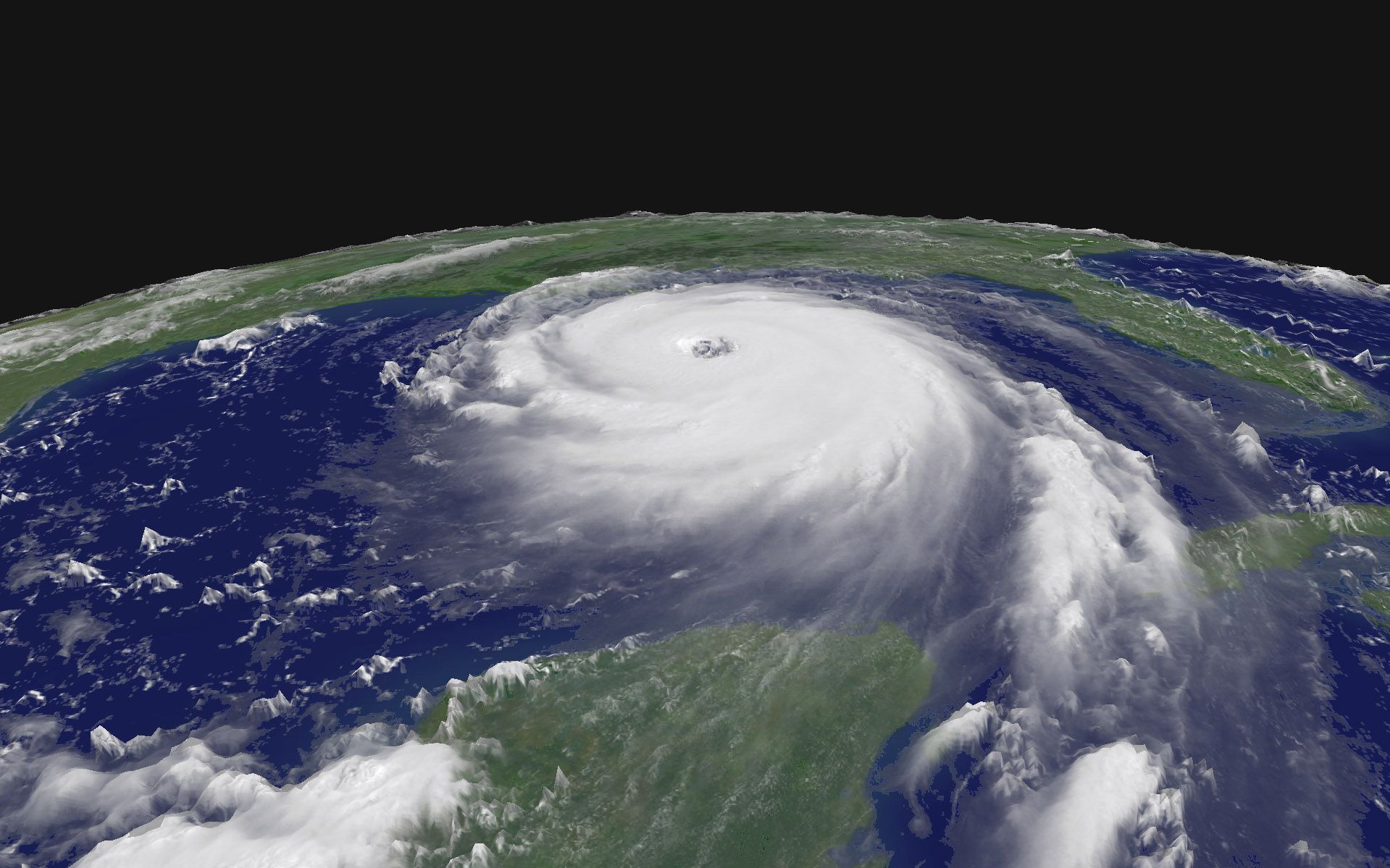
The hurricane center’s forecast track showed Jerry reaching wind speeds of 90 mph as it neared the Leeward Islands on Thursday night, October 9th, and Friday, October 10th. This potential wind intensity positioned Jerry as a significant threat to any landmasses in its immediate path, prompting urgent advisories for those in the region.
While most forecast models kept Jerry below major hurricane strength, there was even a slim possibility mentioned that it could briefly reach Category 3 intensity, with winds of at least 111 mph. This demonstrated the range of potential outcomes considered during Jerry’s early, more robust forecast period.
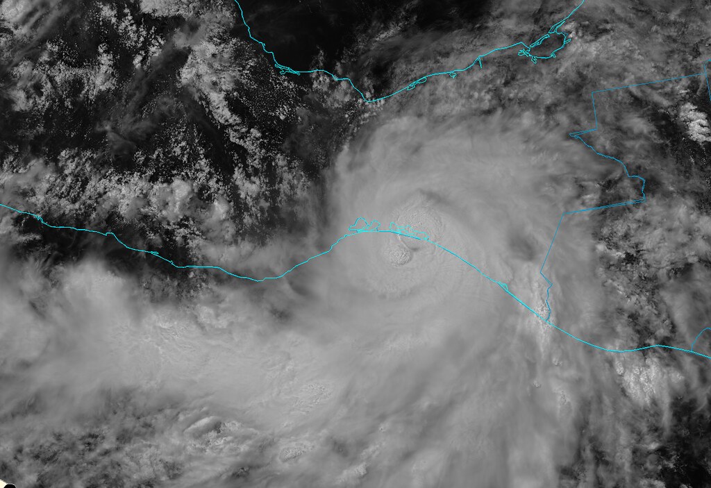
3. **Initial Threat to the Northern Leeward Islands**As Tropical Storm Jerry tracked west-northwest, it became clear that the northern Leeward Islands were squarely in its crosshairs. Forecasters warned that tropical storm conditions were possible later today into Friday on portions of these islands as Jerry passed nearby.
Tropical storm warnings were promptly put into effect for Anguilla, Barbuda, Sint Maarten, St. Barthelemy, and St. Martin. Additionally, tropical storm watches were issued for Antigua, Montserrat, Nevis, Saba, St. Eustatius, St. Kitts, Guadalupe, and the adjacent islands, signaling a widespread alert for the region.
On the forecast track, Jerry’s center was expected to pass near or northeast of the northern Leeward Islands later Thursday and into Thursday night. This close proximity necessitated swift preparations from residents and emergency services across the affected territories.
The National Hurricane Center urged people in these areas to continue monitoring the storm’s progress, acknowledging a crucial element of uncertainty. There was “uncertainty on how close” the center of the storm would ultimately get to the islands, adding a layer of suspense to the unfolding situation.
AccuWeather also classified the area as a tropical rainstorm early on, even before Jerry formally developed, and was the first known source to draw a map tracking the path of the storm due to these impending impacts. This highlighted the early recognition of the potential threat Jerry posed to the northeastern Caribbean.
Read more about: Atlantic’s First Major Hurricane Threat Emerges: Tropical Storm Erin Set to Intensify, Urging Vigilance for Coastal Residents
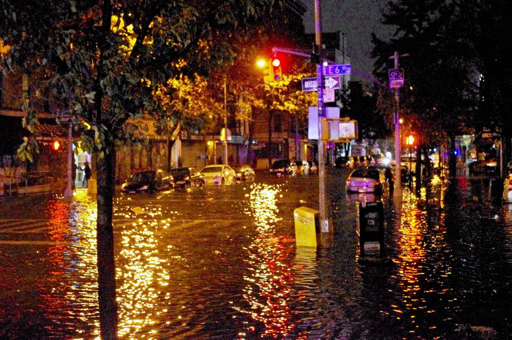
4. **Direct Impacts: Rainfall, Wind, and Dangerous Swells**Even with the uncertainty regarding its exact proximity, the anticipated impacts from Tropical Storm Jerry on the Leeward and Virgin Islands were significant. Forecasters projected substantial rainfall, particularly through Friday, ranging from two to four inches.
Local storm total maxima were expected to reach up to six inches across the Leeward and Virgin Islands. This level of rainfall carried a considerable risk of flash flooding, especially in urban areas and those with steep terrain, where water runoff could quickly become dangerous.
Beyond the deluge, swells generated by Jerry were already beginning to reach the Leeward and Windward Islands. These swells were predicted to spread westward toward the Virgin Islands and Puerto Rico later that night, and then toward the rest of the Greater Antilles over the subsequent couple of days.
These advancing swells were not merely a nuisance; they were likely to cause life-threatening surf and rip current conditions. Such hazards pose serious dangers to coastal communities and marine activities, reinforcing the gravity of the storm’s presence even if its center remained somewhat offshore.
Gusty winds were also expected to accompany Jerry’s closest approach to the islands, generally in the range of 40-60 mph. These winds had the potential to knock down tree branches and toss around unsecured loose items outdoors, adding to the immediate concerns for local infrastructure and safety.

5. **Forecast Track Evolution: Near Islands, Then a Northward Turn**The trajectory of Tropical Storm Jerry was a subject of intense meteorological analysis, with models consistently pointing towards a general northwestward movement followed by a crucial northward turn. Initially, Jerry was expected to pass near or northeast of the northern Leeward Islands.
However, the consensus among forecasts suggested that Jerry would then move off into the Atlantic. The National Hurricane Center’s track showed Jerry was forecast to turn northward as it neared the Leeward Islands, subsequently passing over or to the east of Bermuda.
A key factor influencing this expected curve was a dip in the jet stream along the east coast of the United States. AccuWeather Lead Hurricane Expert Alex DaSilva explained that this atmospheric feature was anticipated to help guide the storm to the north and then curve it out to sea, away from the continental U.S.
Illustrations known as spaghetti models, which compile an array of forecast tools, consistently depicted this general trend. While not all models are created equal, the hurricane center utilizes only the top four or five highest-performing ones to help make its official forecasts, providing a robust basis for these track predictions.
The expectation of this northward and eastward motion was critical for mainland U.S. interests, as it implied Jerry would not pose a direct threat to southern Florida or the U.S. East Coast. This predicted track offered a measure of relief for heavily populated coastal areas, even as the Caribbean faced immediate challenges.
6. **Revisions and Weakening: The Shift from Hurricane to Tropical Storm**In a significant development that underscored the dynamic nature of tropical weather, forecasters revised their outlook for Tropical Storm Jerry. One of the biggest changes from October 9th was that the National Hurricane Center was no longer predicting Jerry would strengthen into a hurricane.
This shift came as Jerry weakened overnight, encountering strong wind shear—a disruptive force that inhibits the organization and intensification of tropical cyclones. The overall intensity was reported to be “nearly flatlined” through the forecast period, with Jerry eventually expected to become extratropical by October 15th.
Maximum sustained winds were now predicted to top out at 60 mph, well short of the 74 mph required for hurricane designation. This marked a considerable downgrade from earlier forecasts that had anticipated Jerry reaching 90 mph or even briefly touching Category 3 intensity.
By Friday afternoon, all tropical storm warnings for the northern Leeward Islands were discontinued as Jerry’s center pulled away from the region. While “trailing bands continue to produce heavy rains” over the islands, the immediate threat of escalating winds had passed.
This change in intensity forecast highlights the continuous reassessment inherent in hurricane prediction, influenced by real-time atmospheric conditions. What once seemed destined for hurricane status, Jerry’s journey took a less intense turn due to environmental factors, a testament to the complexities of hurricane meteorology.
7. **Meteorological Factors Behind Jerry’s Weakening**The initial assertive forecasts predicting Tropical Storm Jerry’s intensification into a hurricane underwent a crucial revision, primarily due to Jerry encountering strong wind shear. This atmospheric phenomenon disrupts a storm’s structural integrity, acting like an invisible force that tilts its vertical structure, dispersing heat and moisture, and preventing its core from consolidating.
As Jerry moved through areas affected by this disruptive force, its intensity was reported to be “nearly flatlined” throughout the forecast period, struggling to maintain strength. Such conditions hinder the deep convection and tight spiral banding crucial for tropical cyclone development. Consequently, maximum sustained winds were revised downward to 60 mph, well below the 74 mph hurricane threshold, a considerable downgrade from earlier predictions of 90 mph or even Category 3 intensity.
This continuous reassessment, driven by real-time atmospheric data, underscores the fluid and complex nature of tropical meteorology. What once seemed destined for hurricane status pivoted to a less intense trajectory, a testament to how environmental factors dynamically shape a storm’s destiny. The interplay of warm waters, moisture, and inhibiting forces like wind shear dictates this unpredictable dance, demanding constant vigilance from forecasters.
8. **Jerry’s Place in the 2025 Atlantic Hurricane Season**Tropical Storm Jerry’s journey is a thread woven into the larger tapestry of the 2025 Atlantic hurricane season, marking its formation as the 10th named storm. Its narrative offers valuable insights into the broader patterns that have defined this particular year, allowing for comparison with other storms of the season.
Described as a “relatively quiet hurricane season,” only one of the nine other named storms – Chantal – made U.S. landfall, providing context for Jerry’s mostly offshore track. The season also featured Andrea, Barry, Dexter, Fernand, and hurricanes Erin, Gabrielle, Humberto, and Imelda, each with distinct paths and impacts.
NOAA’s outlook, revised in August, predicted 13 to 18 named storms and five to nine hurricanes, with up to five Category 5 storms. Jerry’s initial strengthening, followed by its weakening, aligns with the dynamic nature of these forecasts. Its reduced intensity, unlike the destructive potential of Imelda (Category 2) or the coastal collapses from Humberto and Imelda in North Carolina, kept its direct terrestrial threat significantly lower due to atmospheric steering currents.

9. **The Critical Role of Advanced Forecasting Tools**The precise monitoring and ever-evolving predictions surrounding Tropical Storm Jerry vividly illustrate the indispensable role of advanced forecasting tools in modern meteorology. From its initial designation as Invest 95L, a precursor for disturbances under observation, satellite imagery provided critical early insights into its developing structure, allowing forecasters to track clouds, showers, and thunderstorms wrapping around its nascent center. This real-time visual data is fundamental for formal storm classification and initial threat assessments.
Further augmenting observations are “Hurricane Hunters” — specialized NOAA and U.S. Air Force Reserve teams. These crews fly directly into storms to gather invaluable atmospheric data. Scheduled to investigate Jerry, their direct measurements of winds, pressure, and temperature provide highly accurate information, significantly refining intensity and trajectory forecasts beyond satellite capabilities.
Another cornerstone of hurricane prediction is the use of “spaghetti models,” which compile an array of numerical forecast tools. While not all models are created equal, the National Hurricane Center (NHC) meticulously selects and utilizes only the top four or five highest-performing ones. These models offer a probabilistic range of potential tracks, aiding forecasters in identifying the most likely path and anticipating potential deviations.
The continuous updates to Jerry’s forecast, from projected hurricane status to weakening, exemplify these tools’ dynamic nature. They enable meteorologists to make data-driven adjustments, ensuring accurate, up-to-date information. This iterative process of observation, data collection, modeling, and reassessment is paramount for timely warnings and effective preparedness.
Read more about: Beyond Survival: 12 Critical Lessons on Resilience from Those Who Conquered Crisis
10. **Potential Impacts on Bermuda**As Tropical Storm Jerry continued its journey, the focus of potential impacts shifted to Bermuda. Initial forecast tracks from the National Hurricane Center indicated Jerry was “forecast to turn northward as it nears the Leeward Islands, subsequently passing over or to the east of Bermuda,” placing the island nation within the storm’s potential sphere of influence.
Further advisories noted that “by the end of the upcoming weekend, Jerry could track close enough to Bermuda to bring some impacts,” underscoring the need for close monitoring. However, as Jerry’s track became more defined and its intensity revised, the likelihood of severe impacts diminished. AccuWeather Lead Hurricane Expert Alex DaSilva suggested “impacts to Bermuda are not out of the question, but it appears more likely that the storm will pass well to the east of the islands.”
This updated outlook offered relief, indicating that while Jerry might still bring periphery effects, its core was less likely to pose a direct threat. The anticipated northward and eastward curve, driven by features like the dip in the jet stream, played a critical role in steering Jerry away from a direct confrontation with the island, showcasing how distant meteorological phenomena influence localized events thousands of miles away.
Read more about: Smart Savings on Wheels: Unveiling the 10 Best Value Used Cars for Frugal Shoppers, Backed by Dealer Insights and Long-Term Records
11. **Potential Impacts on the U.S. East Coast and Comparisons to Other Storms**From its early stages, a consistent theme in Tropical Storm Jerry’s forecast was its projected trajectory away from the continental United States. The National Hurricane Center explicitly stated that Jerry “wasn’t posing any threat to southern Florida,” and AccuWeather experts confirmed that a “dip in the jet stream is expected to turn Jerry to the north and then curve it out to sea, keeping it away from North Carolina and the U.S.” This northward and eastward motion was a significant relief for heavily populated coastal areas.
The 2025 Atlantic hurricane season had already presented its share of challenges to the U.S. East Coast, even without direct landfalls from every storm. For instance, Hurricanes Humberto and Imelda, both stirring up the ocean well offshore, had already caused “destructive surf, causing multiple coastal homes in North Carolina’s Outer Banks to collapse.” This illustrated that even distant storms could generate significant and hazardous coastal conditions, underscoring the ongoing vigilance required for any major Atlantic system.
Comparatively, Jerry was expected to curve north, similar to Hurricanes Erin and Humberto, staying away from the U.S. Erin, a “major hurricane,” remained 200 miles off North Carolina. The rare Fujiwhara effect, with Humberto passing near Imelda, “helped to pull the smaller storm away from the U.S. coast and out to sea,” sparing the Southeast from Imelda’s major flooding.
While Jerry posed no direct U.S. threat, distant storms stirring the Atlantic remained a concern. Discussions consistently reassured Jerry’s track would diverge from the U.S. coastline, unlike other systems that brought significant coastal erosion and dangerous surf to North Carolina’s Outer Banks. This season demonstrated that hurricane impacts extend beyond landfall, encompassing broad ocean-generated hazards.

12. **Outlook on the Remainder of the 2025 Hurricane Period**As Tropical Storm Jerry’s narrative unfolded and began to wind down, meteorologists were already looking ahead to the remaining weeks of the 2025 Atlantic hurricane season. The season officially runs from June 1 through November 30, meaning a significant portion, “about 25% of this year’s Atlantic hurricane season,” was yet to come even as Jerry dissipated. This fact served as a stark reminder that vigilance cannot wane, as atmospheric conditions can remain conducive to tropical cyclone formation well into the late autumn months.
Forecasters had already predicted a potentially busy latter half of the season. AccuWeather Lead Hurricane Expert Alex DaSilva reiterated this, stating, “We have been forecasting a more active second half of the hurricane season since the spring.” This outlook cautioned against complacency, especially since the “peak of hurricane season,” which runs from mid-August through mid-October, was still very much active or had only recently passed. The expectation was for atmospheric conditions that “could support tropical storms and hurricanes well into late October and November this year.”
Furthermore, the meteorological community remained actively engaged in monitoring other potential systems across different basins. In the Eastern Pacific Ocean, for instance, the basin was already up to 16 named storms, including 10 hurricanes, with Tropical Storm Octave making a complete U-turn and Hurricane Priscilla forecast to make landfall along the Baja California coast. Though geographically distinct, these parallel activities underscored the global nature of tropical weather phenomena and the continuous efforts required for monitoring.
Closer to the Atlantic, the NHC watched a disturbed area over the Bay of Campeche, expected to bring heavy rains to Belize, Yucatan, and southern Mexico, despite minimal formation chances. This ongoing activity, coupled with Atlantic long-term forecasts, reinforced the message for communities to “not let your guard down” as the season approached its end, preparing for continued meteorological developments.
**The Dynamic Dance of Nature’s Fury**
Read more about: From Cereal to Skiing: 15 Everyday Joys The Rich Have Unintentionally Transformed, Making Them Unattainable for Many
The journey of Tropical Storm Jerry, from its rapid genesis to its eventual weakening and northward curve, encapsulates the profound dynamism and inherent unpredictability of the Atlantic hurricane season. It serves as a compelling narrative, reminding us that each named storm carves its own unique path, influenced by a complex interplay of environmental factors that are constantly shifting. While Jerry ultimately spared the U.S. mainland from direct impacts, its existence highlighted the critical need for advanced forecasting tools, the tireless work of meteorologists, and the enduring importance of community preparedness. As the 2025 season continues its course towards its official close, the lessons learned from Jerry, and indeed all its counterparts, resonate deeply: nature’s power demands our respect, our vigilance, and our continuous adaptation to its magnificent and sometimes formidable dance.


