


The 2025 Atlantic hurricane season has seen its first major hurricane with the remarkable and at times volatile journey of Hurricane Erin. This powerful storm captivated meteorologists and coastal communities as it intensified with historic speed, traversed the Atlantic, and ultimately brought significant impacts to the U.S. East Coast. Its progression, from a tropical wave off West Africa to a Category 5 behemoth, underscored the dynamic and unpredictable nature of these formidable weather systems. The Saffir–Simpson scale, a critical tool in hurricane analysis, defines various intensities ranging from Tropical depression (≤38 mph) to Category 5 (≥157 mph), providing a framework to understand Erin’s monumental shifts.
Erin’s track and intensity fluctuations were closely monitored using the Saffir–Simpson scale, which categorizes hurricanes based on sustained wind speeds. From its origins as a tropical depression to its peak as a Category 5, Erin demonstrated the full spectrum of hurricane development and decay. This detailed account examines the critical junctures of Hurricane Erin’s lifecycle, outlining its formation, unprecedented intensification, and extensive impact on vulnerable regions. The information presented herein is based on reports from the National Hurricane Center (NHC), ABC News, CBS News, and USA TODAY.
As the Atlantic hurricane season, which runs through November and typically peaks between mid-August and mid-October, continues to unfold, Erin stands as a stark reminder of the forces at play. Forecasters with the U.S. National Oceanic and Atmospheric Administration (NOAA) had predicted an above-normal season for the Atlantic, expecting between 13 and 18 named storms, with five to nine becoming hurricanes and two to five becoming major hurricanes. Erin’s trajectory and strength have certainly contributed to these active season projections, signaling a period of heightened vigilance for coastal residents and emergency services.

1. **Origin and Early Development**The genesis of what would become Hurricane Erin was first observed on August 8, when the National Hurricane Center (NHC) commenced monitoring a westward-moving tropical wave. This wave originated just inland of the coast of West Africa, already demonstrating a substantial area of shower and thunderstorm activity. This nascent disturbance approached the Atlantic Ocean, marking the very beginning of Erin’s eventual monumental journey.
As this system transitioned from land to sea, moving towards the Cape Verde Islands the following day, meteorologists noted significant organizational changes. A large, well-defined low-pressure system began to develop in direct association with the tropical wave. This developing low was characterized by disorganized convection, indicating ongoing atmospheric instability, and was already producing sustained near gale-force winds.
These initial observations provided crucial insights into the potential for further development. The presence of a well-defined low and persistent convection signaled that the atmospheric conditions, while still nascent, were conducive to cyclogenesis. The system’s westward trajectory meant it was moving into open Atlantic waters, an environment where tropical cyclones often find the necessary fuel to intensify.
Read more about: Engineering Nightmares: 15 Vehicles So Flawed, Owners Still Regret Buying Them

2. **Tropical Storm Erin’s Emergence**By the morning of August 11, the system had undergone sufficient organization to earn its designation as a tropical storm. A small but persistent patch of deep convection developed around its now-closed center, a key indicator of strengthening. Sustained winds within the system had increased to approximately 45 mph (75 km/h), surpassing the 39 mph threshold for a tropical storm designation, according to the Saffir-Simpson scale.
Consequently, the NHC officially named the system Tropical Storm Erin. This marked a significant milestone in its development, as it transitioned from a mere tropical disturbance to a recognized named storm. The naming process alerts the public and provides a clear identifier for tracking and communication regarding the storm’s progression and potential threats.
However, Erin’s initial rapid westward movement after forming led it into a challenging thermodynamic environment. This less-than-ideal atmospheric setting inhibited further immediate development, suggesting that the storm would face obstacles in its path to greater intensity. Such environmental factors, including wind shear and dry air, often play a crucial role in shaping a tropical cyclone’s fate.
3. **Path to Hurricane Status**Despite the initial setbacks and a less than ideal environment, Erin demonstrated resilience. On August 12, the storm was unable to become noticeably better organized, and deep convection decreased during the morning, reflecting the challenging conditions it faced. The presence of a poor thermodynamic environment can severely limit a storm’s ability to maintain or increase its strength.
Conditions around the storm remained only marginally conducive on August 13. However, a notable shift occurred as the convection became more concentrated near Erin’s center, a vital sign of internal restructuring and strengthening. This allowed Erin to strengthen slightly that afternoon, indicating its capacity to overcome some of the environmental impediments.
Persistent dry air entrainment continued to challenge the storm on August 14, hindering its ability to establish a robust inner core. Convection diminished somewhat over the low-level center late that day, suggesting a continued struggle. Nevertheless, through these fluctuating conditions, Erin was able to strengthen into a Category 1 hurricane by 15:00 UTC on August 15, signifying sustained winds of 74-95 mph.
Read more about: The 14 Most Spectacular Automotive Failures: Brands That Collapsed After Decades of Dreams

4. **Explosive Intensification to Major Hurricane**Later on August 15, a dramatic transformation began to unfold. Erin’s satellite presentation improved significantly, and a small, distinct pinhole eye became apparent, signaling a more intense and organized core. This development often precedes rapid intensification in powerful tropical cyclones, indicating that the storm was tapping into favorable environmental conditions.
Following this improvement, Erin underwent what meteorologists term “explosive intensification” overnight. This rapid strengthening propelled it to major hurricane status early on August 16, escalating quickly beyond a Category 2 (96-110 mph) and Category 3 (111-129 mph) threshold. A major hurricane is defined as Category 3 or higher on the Saffir-Simpson scale, posing a much greater threat due to its destructive potential.
This rapid escalation underscored the unpredictable nature of tropical cyclones, where periods of slow development can quickly give way to intense strengthening. The formation of a well-defined eye and the dramatic increase in wind speeds demonstrated Erin’s powerful capabilities when conditions aligned for optimal development, setting the stage for its peak intensity.
Read more about: Russia’s Nuclear Calculus: Assessing the Escalation Risk Amidst Global Tensions and Doctrine Shifts
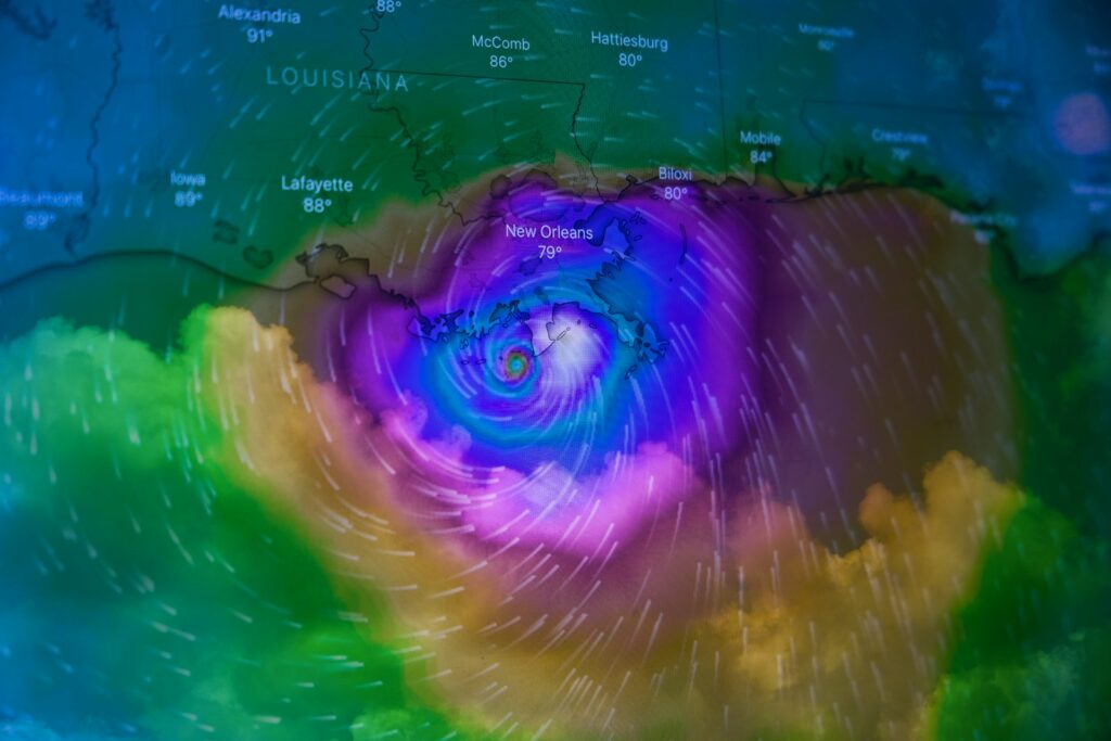
5. **Reaching Category 5 Peak**The explosive intensification culminated in Erin reaching its peak as a Category 5 hurricane by 15:20 UTC on August 16. At this point, it attained maximum sustained winds of a staggering 160 mph (260 km/h) and a minimum central pressure of 915 mbar (27.02 inHg), positioning it about 135 mi (220 km) north-northwest of Anguilla. Category 5 is the highest rating on the Saffir-Simpson scale, signifying catastrophic potential.
At its zenith, Erin exhibited an expansive windfield, with hurricane-force winds extending up to 30 mi (45 km) out from the center. Tropical-storm-force winds, still dangerous, extended much further, up to 160 mi (260 km) out. This vast reach meant that areas far from the immediate eye were still experiencing significant impacts, highlighting the storm’s immense scale and power.
Erin’s 24-hour intensification was particularly noteworthy, marking it as the greatest of any Atlantic hurricane on record based on its drop in central pressure before September 1. This historic achievement underscored the extraordinary atmospheric conditions that fueled its rapid growth and solidified its place as one of the most remarkable storms of the Atlantic season.
Read more about: 11 Cars So Problematic, Owners Are Seriously Wishing for an ‘Insurance Event’ (If You Catch Our Drift)
6. **First Weakening and Eyewall Replacement Cycle**After maintaining its Category 5 intensity for much of August 16, Erin began a process known as an eyewall replacement cycle (ERC). This natural phenomenon in intense hurricanes involves the formation of a new, larger eyewall outside the existing one, causing the inner eyewall to collapse. Both Air Force Reserve and NOAA reconnaissance missions noted the presence of concentric eyewalls at Erin’s core, confirming the cycle was underway.
The commencement of this cycle typically leads to a temporary weakening of the storm, as its energy is distributed over a larger area. Consequently, Erin weakened to a Category 4 intensity during this process. Further weakening continued overnight into the early morning hours of August 17, bringing the storm down to a Category 3 designation.
During this replacement cycle, the storm also grew significantly in physical size. The eye wall diameter increased from an initial 6–12 mi (9–19 km) to approximately 45 mi (75 km). Concurrently, Erin’s hurricane-force windfield expanded to about 50 mi (85 km) from the center, and its tropical storm-force winds extended outward up to 205 mi (335 km), making it a much larger system impacting a broader area.

7. **Secondary Reintensification and Track Adjustments**Following the completion of its eyewall replacement cycle, Erin demonstrated its resilience once more by reintensifying. Late on August 17, the storm strengthened back to Category 4 status, recovering a significant portion of its previous power. This reintensification showcased the storm’s ability to reorganize and regain strength after a period of structural adjustment, a common characteristic of powerful hurricanes.
By August 18, Erin reached a secondary peak intensity, characterized by sustained winds of 140 mph (220 km/h) and a central pressure of 933 mbar (27.55 inHg). This second surge of strength was impressive, confirming its persistent formidable nature. At this time, Hurricane Erin was observed east of the Bahamas, continuing its track towards the northwest.
However, later on that same day, the system weakened again to Category 3 as it continued its northwestward trajectory. This fluctuation in strength, though common, kept forecasters and coastal residents vigilant, highlighting the dynamic and often unpredictable evolution of major hurricanes. The storm’s path eastward of the Bahamas meant continued monitoring for potential impacts on surrounding landmasses. The National Hurricane Center stated as of Saturday night, Hurricane Erin had weakened into a Category 4 storm with maximum sustained winds of 140 mph, and fluctuations in the storm’s intensity were expected.

8. **Continued Fluctuations and Approaching the U.S. East Coast**Following its secondary peak intensity, Hurricane Erin continued to experience fluctuations in strength. On the afternoon of August 19, the storm weakened to Category 2, primarily due to strong wind shear disrupting its structure. This allowed dry air to infiltrate the northwestern part of its circulation, hindering its organization.
Despite these environmental challenges, Erin demonstrated resilience once again. As it moved over warm waters with abundant moisture, the storm reintensified to a high-end Category 2 hurricane on the morning of August 20. Overnight, Erin also shifted its trajectory, turning toward the east-northeast, while its broad windfield continued to expand, with tropical storm-force winds extending up to 300 miles out from its center.
Meteorological models consistently predicted Erin would track between Bermuda and the U.S. East Coast, generally staying hundreds of miles offshore. However, forecasters warned that large waves and life-threatening rip currents were still expected to impact the coast from August 20 to August 27, posing a significant threat to marine and coastal areas.

9. **Closest Approach to North Carolina and Bermuda**As Erin continued its journey, it made its closest approach to the Outer Banks of North Carolina at 06:00 UTC on August 21. The storm passed approximately 200 miles southeast of Cape Hatteras. Simultaneously, it was located about 465 miles west-northwest of Bermuda, signifying its position relative to key coastal and island communities.
During this period, tropical storm conditions were reported to be in effect over parts of North Carolina’s Outer Banks and along the coast of Virginia. Residents and tourists in Bermuda were also advised to stay out of the water, with rough seas anticipated through Friday. These advisories underscored the widespread impact of Erin’s expansive windfield, even at a considerable distance from its core.
The National Hurricane Center had forecast that the center of Erin would move over the western Atlantic between the U.S. East Coast and Bermuda through Wednesday and Thursday. This trajectory maintained the storm’s influence over a broad maritime area, necessitating ongoing vigilance for communities in its path.

10. **Extratropical Transition and Dissipation**By the morning of August 22, Hurricane Erin began a significant transformation as it moved northeastward over open waters, midway between Bermuda and Nova Scotia. The storm weakened to Category 1 strength, influenced by 35–40 mph southwesterly wind shear and substantial cold air advection. These factors initiated its transition into an extratropical cyclone.
Erin completed its extratropical transition that afternoon, approximately 260 miles south of Sable Island, Nova Scotia. Despite becoming a post-tropical cyclone, the system was expected to remain a “large and powerful hurricane-force low-pressure system through the weekend,” according to the National Hurricane Center.
The final advisory on Erin, issued at 5 p.m. ET on Friday, August 22, noted the storm had maximum sustained winds of 90 mph and was moving east-northeast at 33 mph. Its center was then about 375 miles south-southwest of Halifax, Canada, as it continued to move out over the North Atlantic, signaling the end of its lifecycle as a tropical system.

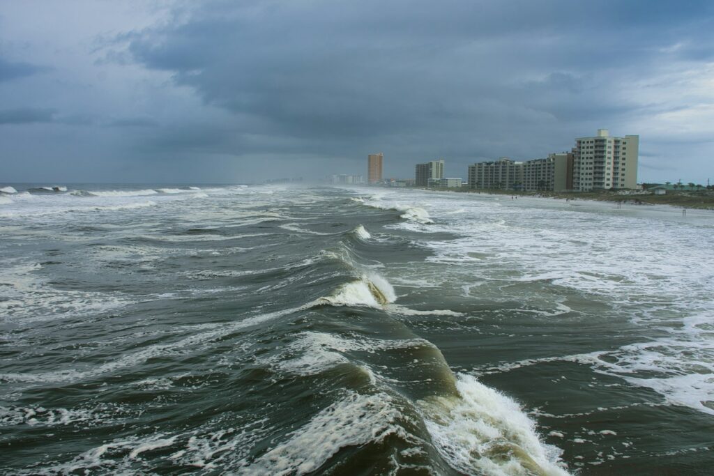
11. **Widespread Coastal Impacts and Marine Dangers**Even as Hurricane Erin moved away from the U.S. East Coast, its distant presence generated widespread coastal impacts and significant marine dangers. Large waves and life-threatening rip currents were predicted to affect the coast from August 20 to August 27. This posed a serious threat to anyone entering the waters and potentially to coastal property.
Coastal erosion, particularly along North Carolina’s Outer Banks, emerged as a serious concern, with waves of 8 to 12 feet forecast. Other areas, including South Carolina and Virginia, could experience waves reaching 6 feet. Hurricane Center Director Michael Brennan warned that offshore wave heights could exceed 20 to 30 feet, creating extremely dangerous conditions in the surf zone from East Central Florida to Canada’s Atlantic Coast.
Brennan emphasized the importance of taking Erin’s potential coastal impacts seriously, even without a direct U.S. landfall. He stated that it would “not be a safe environment to be in the ocean,” cautioning that dangerous and possibly life-threatening rip currents could be present even when onshore weather appeared pleasant.
Read more about: Urgent Safety Alert: 14 Critical Vehicle Recalls Drivers Must Understand Now
12. **Mandatory Evacuations and Preparatory Measures**In response to Erin’s advancing coastal threats, officials implemented mandatory evacuation orders and preparatory measures in vulnerable regions. Evacuations were ordered for Hatteras Island and Ocracoke Island in North Carolina’s Outer Banks ahead of anticipated high waves and flooding. North Carolina Gov. Josh Stein declared a state of emergency on Tuesday afternoon to mobilize resources and assist with the response efforts.
Officials in Dare County issued warnings that crucial roads, including the main exit route, N.C. Highway 12, could soon become impassable due to overwhelming water. A mandatory evacuation order for Ocracoke Island went into effect on Tuesday, with residents and visitors urged to evacuate immediately as the “window to safely evacuate is closing quickly.”
The villages under evacuation on Hatteras Island included Rodanthe, Waves, Salvo, Avon, Buxton, Frisco, and Hatteras. County officials highlighted that coastal flooding and overwash had already begun along vulnerable stretches of N.C. Highway 12 and were expected to worsen with subsequent high tides. In anticipation of prolonged inundation, transportation to a shelter in Warren County was made available for evacuees, who were advised to bring clothing and medications for seven days.
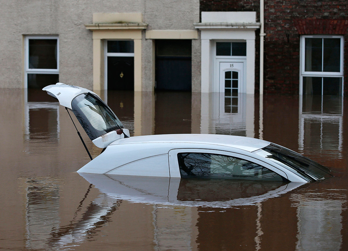
13. **Localized Flooding and Road Impassability**Hurricane Erin brought tangible impacts to coastal areas, including localized flooding and road impassability. Tropical storm conditions and heavy rain reached parts of North Carolina’s Outer Banks on Thursday, leading to coastal flooding in Virginia, as reported by CBS Richmond affiliate WTKR-TV. Further north, areas of the New York City borough of Queens and Long Island also experienced flooding.
The National Hurricane Center warned that the storm surge, coupled with large waves, would lead to “significant beach erosion and overwash, making some roads impassible.” The National Weather Service office in Newport/Morehead City, which covers the Outer Banks, specifically warned that the crucial Highway 12 in Buxton was already showing signs of flooding two hours before high tide on Tuesday.
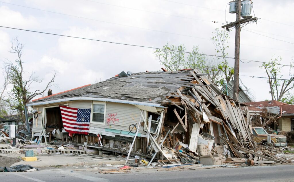
Forecasters predicted that the storm’s impacts would be prolonged, with certain roads being impassable or inaccessible for days, and warned that “vehicles will likely be submerged.” Indeed, by Wednesday evening, officials had closed Highway 12 on Hatteras Island as surges increased, and the road remained closed Thursday. Ocracoke Island’s connection to its ferry terminal was also severed due to the conditions. Melinda Meadows, a property manager at the Cape Hatteras Motel in Buxton, reported that a door was ripped off a townhouse, walls were knocked out, and heat pumps were washed away by the water’s force.

14. **Extensive Beach Closures and Rescue Operations**Throughout the East Coast, safety precautions led to extensive beach closures and a surge in rescue operations. Numerous beaches, stretching from South Florida to New England, implemented swimming bans and closures to protect the public from dangerous surf conditions and rip currents. Vacationers in North Carolina, parts of New Jersey, Delaware, and New York City were forced to abandon plans for swimming.
New York Mayor Eric Adams announced that all city beaches would be closed for swimming on Wednesday and Thursday due to dangerous rip currents. New Jersey Gov. Phil Murphy similarly urged visitors and residents to avoid entering the ocean. Officials in towns like Cape May, Ocean City, and Longport explicitly ordered beachgoers to stay out of the water, with Ocean City’s Beach Patrol declaring, “Conditions are deadly. Do not enter the ocean until further notice.”
Despite warnings, lifeguards were actively engaged in rescuing dozens of people from the churning waters. In North Carolina, at least 60 individuals were rescued from rip currents at Wrightsville Beach, leading to a no-swim order for the remainder of the week. Additionally, one person was rescued from a rip current at a South Carolina beach, and a dozen rip current reports were made across South Carolina and Georgia beaches on August 18, underscoring the widespread and potentially deadly threat posed by the powerful currents.
Read more about: Beyond the Pass: An In-Depth Look at Why 13 Esteemed Chefs Faced Significant Restaurant Closures

15. **Context of the Atlantic Hurricane Season**Hurricane Erin emerged within an Atlantic hurricane season that the U.S. National Oceanic and Atmospheric Administration (NOAA) had forecast to be above-normal. NOAA predicted between 13 and 18 named storms, with five to nine expected to become hurricanes and two to five reaching major hurricane status. Erin, as the fifth named storm of the 2025 Atlantic hurricane season, certainly contributed to these active season projections.
The Atlantic hurricane season officially runs from June 1 through November 30, with peak activity typically occurring between mid-August and mid-October. Erin’s impactful journey highlights the dynamic nature of this period, reinforcing the need for ongoing vigilance for coastal communities and emergency services, particularly as the season had yet to reach its midpoint.
While Erin’s formation was historically significant due to its rapid intensification, experts like Dan Brown, branch chief of the National Hurricane Center’s hurricane specialists, noted that its development does not necessarily dictate what will happen later in the season. However, Levi Silvers, a research scientist at Colorado State University, offered a sobering reminder: it only takes one intense landfalling hurricane to result in a disastrous season. Furthermore, forecasters continued to monitor additional tropical systems, with two more disturbances lurking in the Atlantic, one of which had a 60% chance of developing, ensuring the continuation of an active and closely watched season.
Read more about: America Unveiled: A Deep Dive into the United States’ Enduring Story, Landscapes, and Institutions
The journey of Hurricane Erin stands as a testament to the raw power and unpredictable nature of Atlantic tropical systems. From its rapid intensification to its wide-ranging coastal impacts, Erin served as a powerful reminder of the importance of preparedness and constant monitoring in hurricane-prone regions. As the 2025 Atlantic hurricane season continues to unfold, Erin’s legacy will undoubtedly inform future readiness efforts, reinforcing the critical role of timely forecasts and public safety measures.
")

