Humankind’s relentless curiosity often pushes us to gaze skyward, dreaming of distant galaxies and uncharted cosmic frontiers. Yet, beneath our very feet lies an equally enigmatic and profound realm: the Earth’s deep interior. This profound fascination with what lies far below the surface has driven us, throughout history, to explore and even create some of the most astonishing deep holes on the planet. These incredible formations offer unparalleled opportunities to unravel the geological mysteries of our world.
Whether carved by the immense, patient forces of nature over countless millennia or meticulously engineered by human ingenuity for scientific discovery, resource extraction, or sheer ambition, these abyssal formations are more than just voids in the ground. They represent breathtaking feats of exploration, revealing invaluable secrets of ancient rock formations, hidden water reservoirs, and even microscopic life that thrives far from the sun’s reach, challenging our preconceptions about subterranean ecosystems.
Join us on an extraordinary expedition into these subterranean wonders, as we embark on a journey into a selection of Earth’s most profound depths. From colossal human-made excavations that have dramatically reshaped landscapes to mysterious natural sinkholes and scientific boreholes that push the very limits of our understanding of the planet’s crust, each remarkable site unveils a unique chapter in the grand narrative of Earth and our endless quest to comprehend its innermost workings.

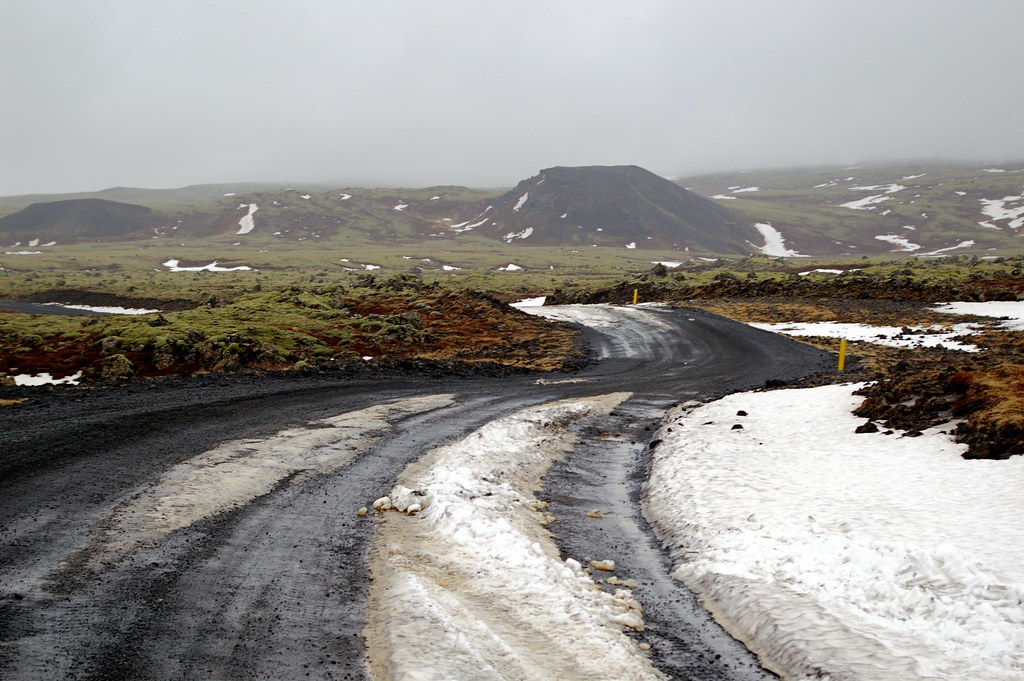
1. **Kola Superdeep Borehole**:The Kola Superdeep Borehole SG-3 stands as an unparalleled testament to human scientific ambition, holding the distinguished title of the deepest human-made hole on Earth since its remarkable achievement in 1979. Located in the remote Pechengsky District of the Kola Peninsula, in close proximity to the Russian border with Norway, this extraordinary endeavor was a pioneering scientific drilling effort initiated by the Soviet Union in 1970. Its ambitious primary goal was to penetrate as deeply as conceivably possible into the Earth’s continental crust, in a monumental effort to unravel geological secrets that lay profoundly beneath the surface.
Despite its relatively modest diameter of only around 9 inches, the borehole plunged to a mind-bending true vertical depth of 12,262 meters (40,230 ft or 7.619 miles) by 1989. This incredible penetration signifies that it reached depths far exceeding the deepest known parts of the ocean, firmly establishing it as the deepest artificial point on Earth. The project, designed as part of a broader Soviet scientific research program, utilized specialized drilling rigs such as the Uralmash-4E and, later, the purpose-built Uralmash-15000, which was aptly named after its audacious target depth of 15,000 meters, showcasing the grand scale of its aspirations.
Throughout its active drilling period, which officially concluded in 1995 due to a cessation of funding, the Kola Superdeep Borehole yielded numerous unexpected and profound geophysical discoveries. Contrary to seismic predictions, scientists never encountered the expected basaltic layers at 7 kilometers down; instead, more granites were found persisting at far greater depths. Astonishingly, water was discovered pooling 3–6 kilometers below the surface, having percolated through the granite until it encountered an impermeable rock layer, and remarkably, this water did not naturally vaporize at any depth within the borehole. Even more surprisingly, microscopic plankton fossils were unearthed 6 kilometers below the surface, and the drilling mud that emerged from the hole was described as “boiling” with an unprecedented level of hydrogen gas, collectively showcasing the unforeseen wonders and complexities of Earth’s deep crust. The project was eventually dissolved in 2007, and the site abandoned, leaving behind a profound legacy of scientific discovery.

2. **Z-44 Chayvo Well**:While the Kola Superdeep Borehole exemplifies vertical depth, the Z-44 Chayvo well represents another pinnacle of human engineering, holding a remarkable record as the world’s longest extended-reach well offshore. This incredible feat of drilling technology is situated on the Russian island of Sakhalin, showcasing the advanced capabilities required for accessing hydrocarbon reserves beneath complex and distant geological formations. It stands as a testament to the ingenuity applied in the challenging offshore environment.
On a significant day, August 27, 2012, Exxon Neftegas Ltd achieved an astonishing milestone by completing the Z-44 Chayvo well, which reached a measured total length of 12,376 meters (40,604 ft). This extraordinary linear reach surpassed the previous record for borehole length, which had been held by the Kola Superdeep Borehole along its bore. This achievement underscored the tremendous progress in directional drilling techniques, allowing access to reservoirs miles away from the drilling platform.
The Z-44 Chayvo well, although having a significantly shallower true vertical depth compared to the Kola borehole, brilliantly illustrates the diverse objectives and formidable challenges inherent in modern deep drilling. Its immense length serves as a prime example of how human innovation continues to push the boundaries of engineering, not just in piercing the Earth downwards, but also in extending horizontally to access vital resources hidden far beneath the Earth’s surface and the vast, often turbulent, ocean floor.

3. **Bingham Canyon Mine**:Shifting our focus from precise, deep boreholes to colossal, open-pit excavations, the Bingham Canyon Mine in Utah stands as an unparalleled monument to human industrial scale, widely recognized as the largest manufactured excavation on Earth. With a rich and extensive history spanning well over a century, this prodigious copper mine has been in continuous production since 1906, profoundly and visibly reshaping the very landscape of the region.
The sheer, breathtaking scale of the Bingham Canyon Mine is truly difficult to fully comprehend. Through decades of relentless operation, it has resulted in the creation of a truly immense pit that plunges dramatically over 0.6 miles (970 meters) deep. This vast chasm stretches an astonishing 2.5 miles (4 kilometers) wide and sprawls across an immense area covering 1,900 acres (3.0 square miles or 7.7 square kilometers). The mine’s internal depth dips down around 3,200 feet, making it not only incredibly wide but also an extraordinarily deep and expansive human-made hole, visible even from space.
This monumental mining operation serves as a powerful illustration of how human endeavors, primarily driven by the global demand for essential resources like copper, can literally carve out and transform geological features on an epic and enduring scale. The Bingham Canyon Mine is far more than simply a hole in the ground; it is a dynamic, living testament to the sheer industrial might and the profound, lasting geological impact of our civilization on the planet.
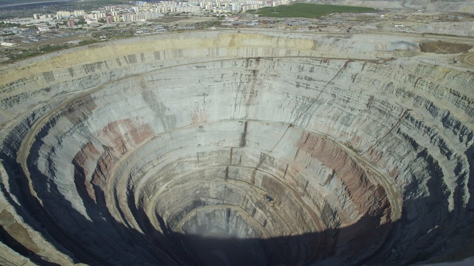
4. **Mirny Diamond Mine**:The Mirny Diamond Mine, nestled in the vast expanse of Russia, represents another awe-inspiring achievement in large-scale excavation, once holding the distinction of being one of the largest diamond mines ever opened in the Soviet Union. Although this formidable mine is no longer in operation, its impressive legacy as a monumental human-made hole continues to resonate, symbolizing a bygone era of intensive resource extraction.
This colossal open-pit mine plunges to a remarkable depth of more than 1,700 feet, creating a dramatic, inverted cone-like structure that captivates observers. Complementing its significant depth, it boasts an incredible diameter of approximately 3,900 feet across its widest point. These vast dimensions firmly solidify its status as the second-largest hole ever excavated on Earth and the fourth deepest open-pit mine globally, a truly gargantuan undertaking for its period of active production.
The Mirny Diamond Mine serves as a stark and powerful reminder of the immense efforts and engineering prowess undertaken to unearth precious resources from the Earth’s crust. Its sheer size and the scale of its creation are a profound testament to the relentless human ambition to acquire wealth and minerals, and the significant, lasting impact that such monumental mining operations have exerted on the planet’s surface and geology.

5. **Udachnaya Pipe Mine**:Journeying once more back to the expansive territories of Russia, specifically to the remote western Yakutia region, we encounter the Udachnaya Pipe Mine, another colossal diamond mine that impressively rivals the Mirny in its sheer magnitude and depth. This massive mine stands as an extraordinary, tangible example of an open-pit operation meticulously designed and executed to unearth incredibly valuable mineral deposits hidden within the Earth.
The Udachnaya Pipe Mine sprawls across an astonishing surface area, stretching an impressive 5,249 feet by 6,561 feet. Moreover, its dramatic depth reaches a staggering 2,099 feet from the rim to the deepest point of the excavation. These immense dimensions collectively place it among the largest and deepest man-made excavations in the world, representing a truly monumental undertaking in the persistent and challenging quest for diamonds.
The mine’s vast size and profound depth vividly underscore the relentless human drive to tap into Earth’s rich and often deeply buried mineral deposits, even when these resources are located in the most remote, challenging, and unforgiving environments. It stands as a powerful and enduring illustration of the transformative power of industrial mining on the natural landscape, a testament to the scale at which human ingenuity can alter the face of the planet.

6. **The Great Blue Hole**:From the realm of human-engineered chasms, our exploration now turns its gaze towards a truly stunning and unique natural wonder: the Great Blue Hole, magnificently situated just off the coast of Belize. This monstrous and captivating hole is not only a world-renowned tourist attraction but also an extraordinary geological formation that continues to mesmerize adventurers, divers, and scientists alike with its profound beauty and hidden depths.
This immense marine sinkhole presents itself as a strikingly perfect circular void in the vibrant, shallow turquoise waters of the Lighthouse Reef Atoll. It stretches approximately 984 feet across its surface, and plunges to a remarkable depth of about 410 feet. Its dark, mysterious depths hold ancient secrets, hinting at periods when it was a dry cave system before sea levels rose. Recent explorations have begun to unravel the mysteries of its geological processes and the unique marine life that thrives within its sheltered, deep environment.
The Great Blue Hole serves as a magnificent and compelling example of nature’s inherent power and artistry in carving out profound and awe-inspiring “holes” in the Earth’s surface, particularly beneath the ocean. It stands as a potent and enduring reminder of the planet’s dynamic geological history, showcasing how eons of natural processes can create breathtaking landscapes, and highlights the profound beauty that can be discovered within its most extraordinary natural formations.
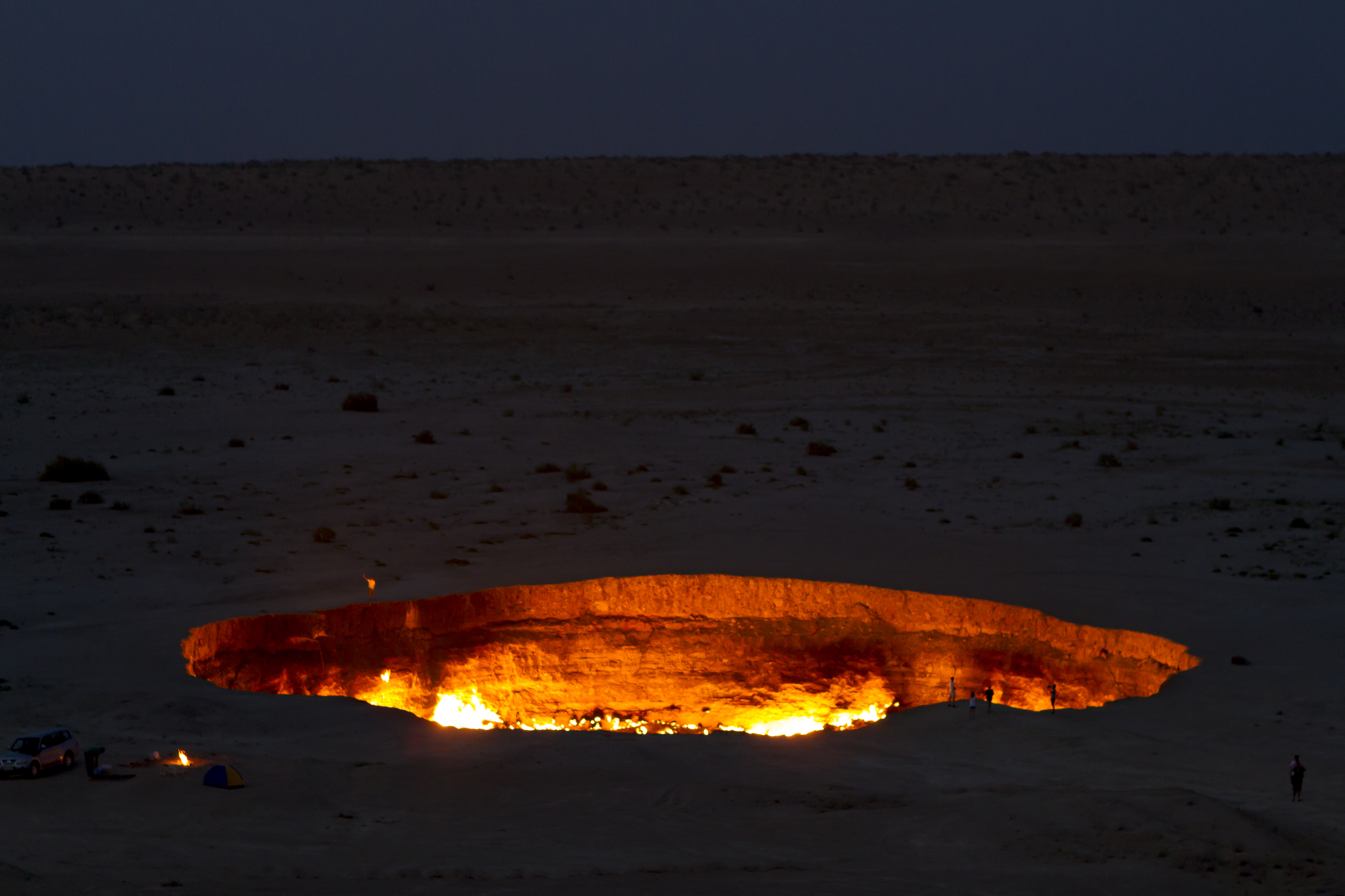
7. **The Darzava Gas Crater**:Our journey into Earth’s profound depths now brings us to another utterly captivating natural phenomenon, one that comes with a spectacular and fiery twist: the Darzava Gas Crater, often dramatically and aptly referred to as the “Door to Hell.” This unique sinkhole, nestled in the arid landscapes of Turkmenistan, holds a distinctive and compelling title as one of the most singular holes in the world, primarily due to its ceaseless and mesmerizing constant inferno.
Approximately four decades ago, during a exploratory drilling project conducted by Soviet scientists in search of natural gas, the ground unexpectedly collapsed, creating this crater. The vast reserves of natural gasses within this newly formed sinkhole were then ignited, reportedly to prevent the spread of toxic methane gas. Ever since that fateful day, the hole has continued burning without cessation, creating a surreal and intensely captivating spectacle that dramatically illuminates the surrounding desert night with its persistent, dancing flames.
Measuring around 230 feet wide and reaching a depth of 100 feet, the Darzava Gas Crater is a powerful, albeit initially unintended, collaboration between significant human activity and potent natural geological processes. It serves as a vivid and unforgettable reminder of the vast, often unseen, reservoirs of natural gas that lie beneath our planet’s surface and the dramatic and enduring consequences that can unfold when these powerful subterranean forces are inadvertently brought to light and ignite, creating a truly unique “deep hole” on Earth.
Our journey into Earth’s remarkable depths continues, moving beyond the initial subterranean wonders to uncover even more astonishing feats of engineering and nature’s profound artistry. From gargantuan copper mines that scar the landscape to groundbreaking scientific observatories nestled deep within ice, and ancient lakes carved by the colossal power of glaciers, these next entries further illuminate the diverse ways in which our planet holds secrets and how we endeavor to uncover them. Each site represents another compelling chapter in our relentless quest to comprehend the Earth’s intricate inner workings and the boundless scale of its natural and human-made marvels.
8. **The Chuquicamata Copper Mine**Venturing to the rugged landscapes of Chile, we encounter Chuquicamata, a name that resonates with unparalleled scale in the world of mining. More commonly known as ‘Chuqui,’ this colossal open-pit operation stands as a testament to the immense global demand for copper. It is widely revered as the mine believed to produce the most copper on Earth, a vital metal indispensable to modern infrastructure and technology. The sheer volume of material extracted here year after year is staggering, reshaping the very topography of the region on an epic scale.
Plunging to an incredible depth of approximately 2,800 feet, Chuquicamata secures its position as one of the most profound human-made excavations ever undertaken. The vastness of this chasm, carved meticulously into the Earth’s crust, is a vivid illustration of human ingenuity and persistence in the face of formidable geological challenges. Its towering terraced walls descend layer by layer, revealing millions of years of geological history, while giant machinery tirelessly works to extract the precious ore that fuels industries worldwide.
This mine is not merely a hole in the ground; it is a dynamic, living monument to industrial might, continually pushing the boundaries of engineering to access deep-seated mineral wealth. The ongoing operation of Chuqui underscores humanity’s profound impact on the planet’s surface, reflecting both our resource needs and our formidable capacity to reshape the natural world in pursuit of progress. It stands as a powerful symbol of the colossal endeavors required to sustain our technological society.

9. **The Berkley Pit**Our expedition now shifts to another formidable copper mine, the Berkley Pit, located in the vast stretches of Montana in the United States. Once a thriving center for copper extraction, this immense open-pit mine bears the scars of intensive human activity, descending to a notable depth of around 1,700 feet. For decades, it played a crucial role in supplying essential resources, contributing significantly to the industrial landscape of the nation and leaving behind a profound mark on the Earth’s surface.
The Berkley Pit ceased active mining operations in 1982, marking a significant turning point in its history. Since its closure, the colossal void has undergone a dramatic transformation, slowly filling with an astonishing volume of groundwater and rainwater. This process has created an immense, acidic lake, which now occupies more than 900 feet of the pit’s depth. The vibrant, often unsettling, colors of the water, a result of dissolved minerals and heavy metals, serve as a stark visual reminder of the mine’s industrial past and its ongoing environmental legacy.
This site stands as a powerful, albeit somber, illustration of the long-term ecological consequences and transformative power of large-scale mining endeavors. It offers a unique window into the lasting geological changes wrought by human hands, showcasing how a deep excavation, once bustling with activity, can evolve into a landscape of stark, profound beauty and complex environmental challenges, reminding us of the enduring impact of our pursuit of buried treasures.

10. **IceCube Neutrino Observatory**From the realm of resource extraction, our journey takes us to the desolate, icy expanse of Antarctica, where a truly unique and profound “hole” serves a purely scientific purpose: the IceCube Neutrino Observatory. Far from the ambitions of mining, this incredible facility is a monumental undertaking dedicated to unraveling the deepest mysteries of the universe. It represents a breathtaking fusion of cutting-edge technology and a profound commitment to fundamental scientific exploration, pushing the boundaries of what is possible in extreme environments.
The creation of this observatory involved an extraordinary engineering feat that spanned more than seven years. Scientists and engineers utilized an innovative hot-water drilling technique to melt a network of deep holes into the Antarctic ice sheet, some reaching depths between 1,450 to 2,450 meters. Within these meticulously created shafts, strings of 60 spherical optical sensors, known as Digital Optical Modules (DOMs), were precisely deployed. Each DOM is equipped with a photomultiplier tube and a single-board data acquisition computer, designed to detect the faint, fleeting signals of high-energy neutrinos originating from distant cosmic events.
IceCube transforms the entire cubic kilometer of pristine Antarctic ice into a giant telescope, allowing researchers to peer into the cosmos in ways never before imagined. By observing these elusive, nearly massless particles, scientists hope to pinpoint the origins of cosmic rays, unravel the nature of dark matter, and gain unprecedented insights into the most energetic phenomena in the universe. This deep hole in the ice is not just an excavation; it is a portal to the fundamental fabric of reality, embodying humanity’s boundless intellectual curiosity and our relentless pursuit of knowledge that transcends Earthly bounds.

11. **Kimberly Diamond Mine**Returning to the rich history of mining, we arrive at the legendary Kimberly Diamond Mine in South Africa, a site that holds the unparalleled distinction of being the world’s largest hand-dug hole. This awe-inspiring testament to human labor and the allure of precious gems began its remarkable transformation in 1871. Over its operational period, it saw an astounding influx of approximately 50,000 miners, who, with pickaxes, shovels, and sheer determination, meticulously carved out this gargantuan depression in the Earth’s crust.
By the time the mine officially ceased operations in 1914, the collective efforts of these tens of thousands of individuals had resulted in a colossal pit nearly 800 feet deep. Its vast, terraced walls, now a geological wonder, narrate a powerful story of human ambition during the diamond rush era. The visible layers of rock and earth bear silent witness to the immense manual labor involved, a stark contrast to the highly mechanized mining operations of today, highlighting a bygone era of intensive, grassroots resource extraction.
The Kimberly Diamond Mine stands not only as an impressive deep hole but also as a profound historical landmark, symbolizing the transformative power of a single valuable resource. It embodies the dreams, struggles, and monumental collective effort of a bygone generation, forever etching their imprint upon the planet. This remarkable site continues to captivate visitors, serving as a powerful reminder of the relentless human drive to unearth wealth from Earth’s depths and the dramatic landscapes that result from such endeavors.

12. **Diavik Mine**Our next destination in the exploration of Earth’s deepest holes transports us to the remote and challenging environment of Canada, where the Diavik Mine stands as a beacon of modern diamond extraction. Owned by the Dominion Diamond Corporation, this mine is an extraordinary example of contemporary engineering applied to the frozen, pristine landscapes of the Canadian North. It proudly holds the title of Canada’s largest diamond mine in terms of production, signifying its critical role in the global diamond supply chain.
The Diavik Mine descends to a remarkable depth of 600 feet, a substantial excavation that places it among the significant deep holes on the planet. Its operation in such an extreme northern climate requires highly specialized techniques and advanced technology, pushing the boundaries of what is achievable in mining. The mine’s unique island location in the middle of Lac de Gras necessitates the construction of massive dikes to hold back the lake waters, allowing access to the diamond-rich kimberlite pipes beneath the lakebed.
This operational marvel is a compelling illustration of how industrial endeavors continue to adapt and innovate to access resources in increasingly challenging environments. The Diavik Mine not only contributes significantly to global diamond production but also showcases the intricate balance between technological prowess and environmental responsibility in the pursuit of valuable minerals from the Earth’s deep, often unforgiving, embrace. It truly represents the cutting edge of deep-earth resource acquisition.
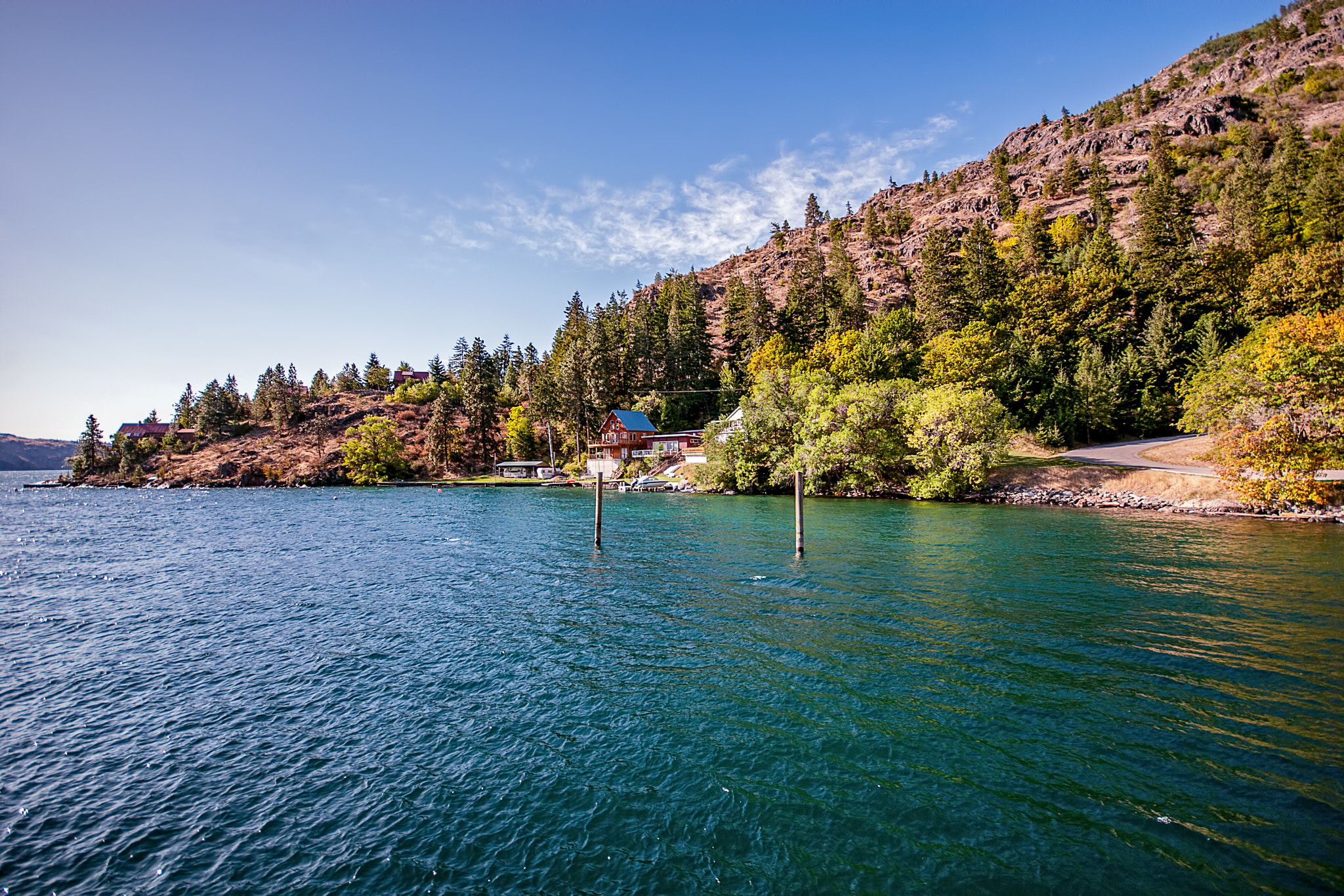
13. **Lake Chelan**Shifting our gaze from human-made excavations, we now turn to a breathtaking natural wonder: Lake Chelan, nestled amidst the stunning Cascade Mountains of Washington State. This impressive body of water is not merely a scenic destination; it is the third-deepest lake in the United States and a magnificent example of a natural glacier-carved lake. Its profound depth and pristine waters are a direct legacy of the immense, grinding power of ancient ice sheets that sculpted the landscape over millennia.
Plunging to an astonishing depth of 1,486 feet, Lake Chelan’s profound basin represents an extraordinary geological feature. Remarkably, despite being situated high in the mountains, the very bottom of this deep lake still lies approximately 285 feet above sea level. This unique characteristic underscores the immense erosive force of the glaciers that once covered this region, carving out a chasm so deep that its lowest point remains elevated above the global ocean surface. The deepest portion of this impressive natural hole is found near the charming town of Chelan, inviting exploration.
Lake Chelan stands as a testament to the raw, patient power of nature. It serves not only as a vital freshwater reservoir but also as a captivating recreational area, drawing visitors to its clear, cool waters and picturesque surroundings. This deep, glacier-sculpted marvel eloquently reminds us that some of the most profound ‘holes’ on Earth are masterpieces of natural processes, creating vital ecosystems and inspiring awe with their timeless beauty and geological significance.

14. **Lake Pend Oreille**Our natural exploration continues to the serene yet profoundly deep waters of Lake Pend Oreille, located in the scenic Idaho Panhandle. This stunning lake, the fifth-deepest in the United States, bears the unmistakable signature of its glacial origins, having been meticulously dug out by massive ice flows countless years ago. Its elongated basin and remarkable depth are vivid evidence of the colossal geological forces that shaped this region, creating a substantial and enduring depression in the Earth’s surface.
Lake Pend Oreille reaches an impressive depth of 1,150 feet, making it a significant natural ‘hole’ that holds a remarkable duality of purpose and appeal. While its northern shoreline is home to the vibrant resort town of Sandpoint, a popular destination for visitors seeking relaxation and outdoor adventures, the lake also serves a highly specialized and discreet function. The southern tip of this massive body of water is an integral part of the U.S. Navy’s acoustic underwater submarine research, a testament to its unique hydrological properties and the immense quietude of its deep waters.
This grand lake thus beautifully encapsulates both recreational enjoyment and critical scientific endeavors, highlighting how deep natural formations can be utilized and appreciated in diverse ways. Lake Pend Oreille stands as a powerful symbol of nature’s artistry in carving profound depths and humanity’s ingenious capacity to harness these natural wonders for both leisure and the advancement of understanding beneath the waves.

15. **Lake Clark**Completing our exploration of Earth’s deepest holes, we arrive at the pristine and remote expanse of Lake Clark, nestled in the southern reaches of Alaska. This magnificent body of water plunges to a depth of 1,056 feet, firmly securing its place among the deepest lakes in the United States. Much like Lake Pend Oreille, Lake Clark is a stunning example of a natural formation painstakingly carved out by the immense, shaping power of glaciers, its waters flowing majestically down from the Chokotonk River valley, near the Kenai Peninsula.
The profound geological significance of Lake Clark is underscored by the establishment of a namesake national park and preserve around its magnificent basin. This designation protects not only the lake’s remarkable depth but also its surrounding pristine wilderness, making it a sanctuary for wildlife and a haven for intrepid adventurers. Despite the absence of a direct parking area, determined visitors make the journey to its shores, eager to immerse themselves in a range of water-based activities, from tranquil kayaking to exhilarating rafting, embracing the raw beauty of its remote setting.
Lake Clark stands as a powerful and enduring testament to nature’s capacity to create profound depths that simultaneously sustain vibrant ecosystems and offer unparalleled opportunities for human connection with the wild. It symbolizes the awe-inspiring grandeur of our planet’s natural ‘holes,’ reminding us of the enduring beauty that lies both on and beneath its surface, inviting us to explore, understand, and protect these precious, deep wonders for generations to come.
Our journey through Earth’s most profound depths, from the colossal excavations forged by human ambition to the awe-inspiring chasms sculpted by nature’s patient hand, reveals a captivating narrative of discovery and transformation. Each deep hole, whether a scientific marvel, an industrial titan, or a pristine natural wonder, serves as a unique window into the planet’s geological past and a testament to our ongoing quest for knowledge and resources. These incredible formations, spanning vast continents and hidden beneath oceans and ice, underscore the boundless mysteries that lie beneath our feet, forever inviting us to look deeper, to understand more, and to marvel at the extraordinary world we inhabit. They are not merely voids but vibrant narratives of Earth’s dynamic history and humanity’s unyielding drive to explore the unseen.

