

Deep beneath the sun-baked plains of East Africa, an extraordinary geological drama is unfolding, largely unseen yet profoundly reshaping the very landscape. Our planet, a vibrant tapestry of moving tectonic plates, is constantly in motion, though these shifts often occur at a pace so slow they escape human perception. Yet, every so often, dramatic events provide vivid clues to the colossal forces at play, revealing that the ground beneath our feet is far from static.
One such compelling testament to Earth’s dynamic nature is the East African Rift System, a vast and complex geological marvel that signals an impending continental breakup. This colossal scar stretches thousands of kilometers, quietly but relentlessly cleaving Africa into two distinct landmasses. It is a process that has captivated scientists for decades, offering an unparalleled opportunity to observe the birth of a new ocean basin in real-time, a phenomenon that typically unfolds across unimaginable stretches of geological time.
Indeed, what we are witnessing in East Africa is not merely a localized phenomenon but a window into the fundamental forces that have shaped our world for eons. From vast stretches of the Red Sea to central Mozambique, the Earth’s crust is responding to immense subterranean pressures, stretching, thinning, and ultimately fracturing. It’s a geological ballet of unparalleled scale, and understanding its intricacies provides profound insights into the very origins of continents and oceans.
1. **The East African Rift: A Continental Divide in the Making**
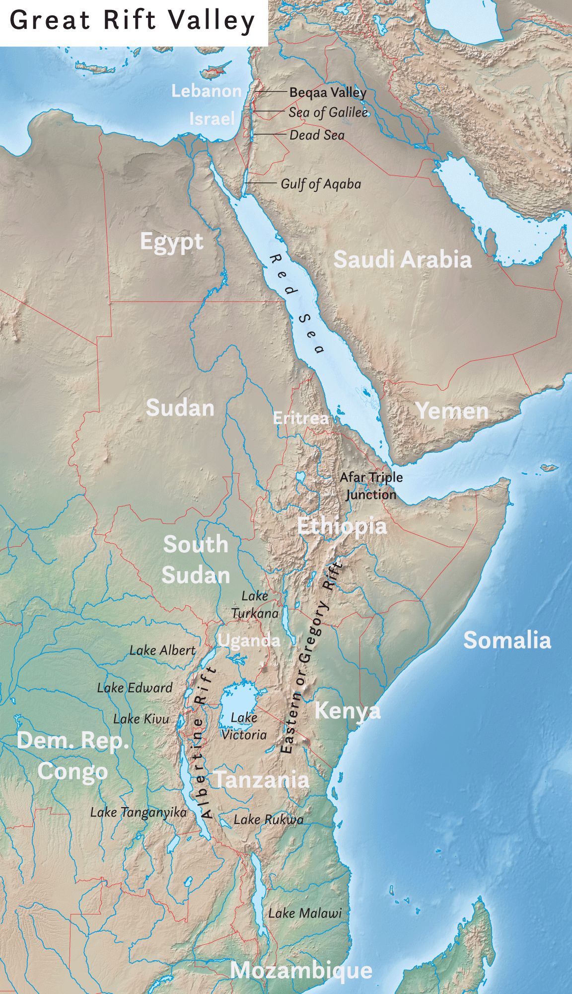
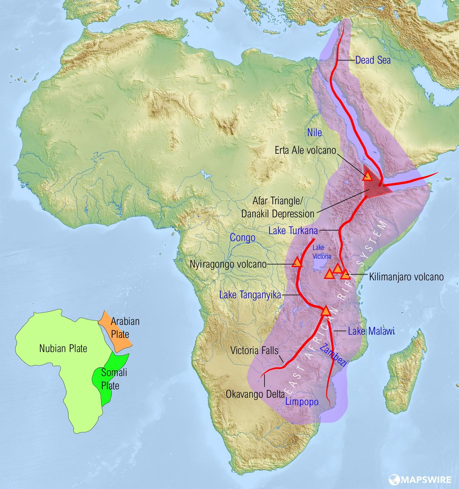
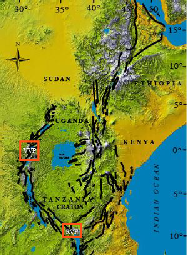
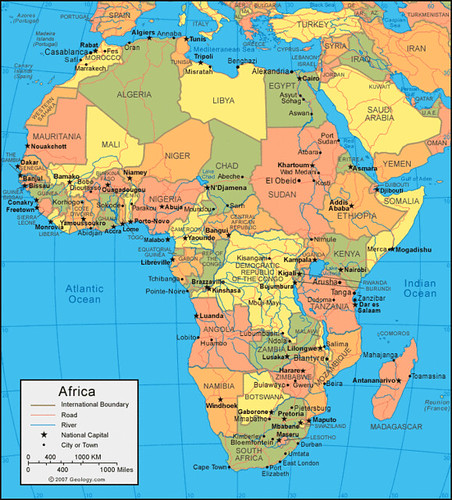
The East African Rift Valley stands as one of Earth’s most renowned geological regions, a sprawling testament to the planet’s continuous transformation. Stretching for an astonishing 3,000 kilometers, from the arid expanses of the Gulf of Aden in the north down to the southern reaches of Mozambique and Zimbabwe, this immense geological feature is actively splitting the formidable African plate into two distinct and unequal parts: the Somali and Nubian plates. This monumental process is a prime example of continental rifting, where colossal forces cause the Earth’s crust to rupture and begin to separate.
Activity along the eastern branch of this vast rift valley, which traverses through Ethiopia, Kenya, and Tanzania, has recently offered striking evidence of these ongoing geological shifts. The sudden appearance of a large, growing crack in south-western Kenya served as a dramatic and undeniable surface manifestation of these deep-seated forces. This event underscored that while the continental breakup is generally imperceptible in human timescales, its effects can occasionally become vividly clear, impacting daily life and infrastructure.
This grand geological division is not a static feature but a vibrant, evolving system, hinting at a future where the current geography of Africa will be irrevocably altered. It represents a living laboratory, showcasing the initial stages of a process that has, over millions of years, given rise to entire ocean basins, fundamentally redrawing the world’s map and shaping the distribution of land and sea as we know it today. The East African Rift is, in essence, a continent in the throes of a profound and slow-motion divorce.
2. **Understanding Continental Rifting and Its Global Significance**
To truly grasp the magnitude of what is occurring in East Africa, it’s essential to understand the fundamental mechanics of rifting itself. When the Earth’s lithosphere—that rigid outer shell comprising the crust and the uppermost part of the mantle—is subjected to a powerful horizontal extensional force, it undergoes a process of stretching and thinning. This relentless pulling eventually causes the lithosphere to rupture, leading to the formation of a distinctive geological depression known as a rift valley. This rupture is not a singular, instantaneous event, but a cumulative response to immense, sustained pressure.
This profound geological process is invariably accompanied by a series of dramatic surface manifestations along the rift valley. These include the widespread presence of volcanism, as molten rock from the mantle rises closer to the surface, and significant seismic activity, as new faults form or existing ones experience renewed movement. Rifts, in essence, represent the very first stage of a continental breakup. If these extensional forces persist and are successful, this initial rupture can progressively widen, ultimately leading to the genesis of an entirely new ocean basin, forever altering the world’s aquatic geography.
A prime and compelling example of this transformative process, having run its full course, can be found in the South Atlantic Ocean. This vast body of water emerged from the dramatic breakup of the supercontinent Gondwana, specifically the separation of South America and Africa, approximately 138 million years ago. It’s a striking demonstration of how rifting, over immense geological timescales, can reshape planetary landscapes, leaving behind tell-tale signs like the remarkable jigsaw-puzzle fit of their respective coastlines. The East African Rift is currently following a similar evolutionary path, albeit in its formative stages.
3. **The Power Source: Africa’s Enigmatic Mantle Superplume**
The colossal forces required to literally tear a continent apart necessitate the existence of extensional stresses powerful enough to fracture the lithosphere. The East African Rift is uniquely characterized as an ‘active’ type of rift, a classification that points to the deep-seated origin of these immense stresses. Rather than being driven primarily by forces at the plate boundaries, the source of this continental pulling lies within the dynamic circulation of the underlying mantle itself—the vast, hot, and viscous layer beneath Earth’s crust.
Beneath the East African Rift, scientists have identified the powerful rise of a large mantle plume, a buoyant upwelling of superheated rock from deep within the Earth. As this mantle plume ascends, it exerts an upward pressure, effectively ‘doming’ the overlying lithosphere. This upward doming causes the lithosphere to weaken significantly, not just through stretching but also as a direct result of the immense increase in temperature. This weakening makes the rigid crust more susceptible to breaking by faulting, initiating the tearing process that defines the rift.
Compelling evidence for the existence of this hotter-than-normal mantle plume has been meticulously gathered through extensive geophysical data. This profound subterranean anomaly is frequently referred to by scientists as the “African Superswell.” This ‘superplume’ is not only a widely accepted and pivotal source of the immense pull-apart forces that are actively forming the East African Rift Valley, but it also provides a crucial explanation for the anomalously high topography observed across the Southern and Eastern African Plateaus, illustrating its pervasive influence on the continent’s geomorphology.
4. **Decoding the Landscape: Distinctive Features of a Rifting Continent**
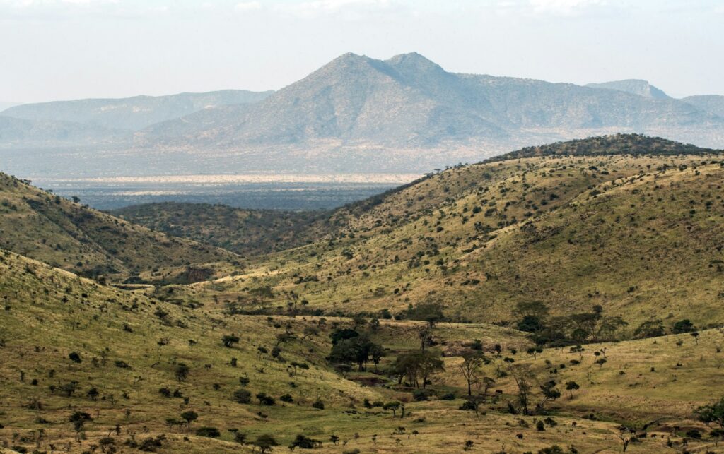
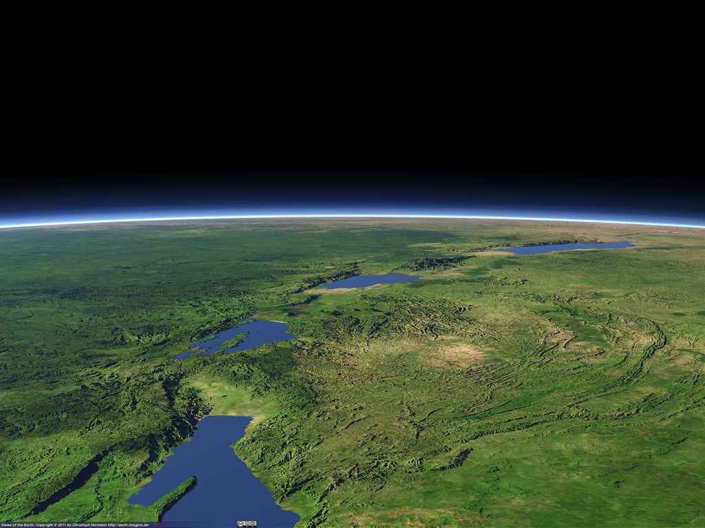
Rifts, by their very nature, exhibit a highly distinctive and recognizable topography that sets them apart from other geological formations. They are characterized by a pronounced series of fault-bounded depressions, often appearing as elongated valleys, which are themselves surrounded by significantly higher terrain. This unique landscape is a direct visual signature of the stretching and fracturing lithosphere. Within the expansive East African Rift system, this characteristic topography is strikingly apparent; a remarkable series of aligned rift valleys, each neatly separated from the others by prominent large bounding faults, can be clearly discerned, even from the distant vantage point of space. This visual clarity underscores the immense scale of the ongoing geological processes.
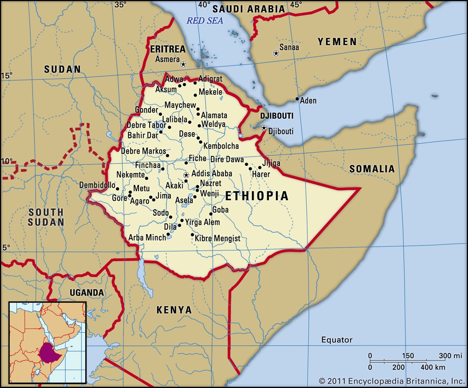
It is important to note that these numerous fractures and valleys did not form simultaneously across the entire rift system. Instead, their formation followed a sequential progression, a gradual propagation through geological time. This process commenced approximately 30 million years ago in the Afar region, located in northern Ethiopia, and has since been steadily propagating southwards towards Zimbabwe. This southward advance occurs at a measurable mean rate, typically ranging between 2.5 and 5 centimeters per year, a pace akin to the growth of fingernails, yet cumulatively transformative over millennia.
While the gradual nature of rifting means it often goes unnoticed in our daily lives, the continuous movement of the Nubian and Somali plates results in tangible effects. The formation of new faults, the opening of fissures and cracks, or the renewed movement along pre-existing old faults can periodically lead to seismic activity. Although the majority of this seismicity across the East African Rift Valley is generally spread over a wide zone and typically of relatively small magnitude, it serves as a constant reminder of the restless ground. Furthermore, the presence of volcanism, running alongside the rift, is another compelling surface manifestation, directly indicating the ongoing process of continental breakup and the proximity of the hot molten asthenosphere to the Earth’s surface.
5. **The Sudden Scar: What Caused Kenya’s Massive Crack?**
In early 2018, a startling event brought the abstract concept of continental rifting into stark, tangible reality for many Kenyans. A massive crack, measuring an astonishing 50 feet deep and 66 feet wide, suddenly appeared in south-western Kenya, causing significant damage to a section of the vital Narok-Nairobi highway. This dramatic rupture immediately sparked widespread discussion and alarm, prompting renewed focus on the ongoing geological processes that could eventually see Africa split into two distinct landmasses. The chasm, stretching for several kilometers, continues to grow, serving as a powerful visual reminder of Earth’s dynamic nature.
Initially, the sudden appearance of this profound crevice was widely linked to the overarching tectonic activity along the East African Rift. While the crack is indeed broadly associated with this regional zone of weakness and the continued breakup of the African continent, geologists now propose a more nuanced explanation for its abrupt visibility. They theorize that the feature is most likely an erosional gully, a channel carved by water, but its formation in that specific location and its sudden, dramatic unveiling are indeed connected to the rift.
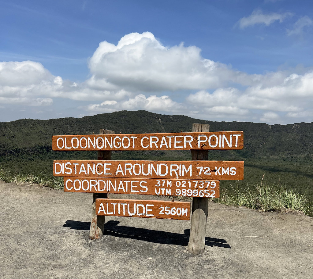
The key to its sudden manifestation lies not solely in tectonic movement but also in environmental factors. Kenya had experienced heavy rainfall, leading to extensive flooding across much of East Africa. Much of the soil in the affected area consists of volcanic ash, likely originating from nearby Mount Longonot. Volcanic ash, by its very nature, is easily susceptible to being washed away. When the torrential rains came, the water found the path of least resistance, following an old, underlying rift-related fault or weakness in the terrain, rapidly eroding the soft infilling soils and dramatically exposing this massive, pre-existing crevice. The incident forced road closures and startled residents, with reports of at least one house splitting in two and a family narrowly escaping their home as it collapsed.
6. **Ethiopia’s Dramatic Fissure: A Precedent for Rapid Change**
The dramatic crack in Kenya, while striking, was not the first sudden and vivid clue to the intense geological activity underlying East Africa. A more profound and even more rapid event unfolded in September 2005, when a colossal fissure, stretching an incredible 35 miles long and reaching up to 25 feet wide, ripped open in the Afar region of Ethiopia. What made this event particularly astounding was its speed: this massive geological feature formed in a mere 10 days, a timeframe that challenged traditional scientific understanding of how swiftly such transformations could occur. This rapid rupture was accompanied by a flurry of seismic activity, with over 420 earthquakes striking the area during that intense period.
This Ethiopian event provided unprecedented insights into the mechanics of continental rifting. Dr. James Hammond of the University of Bristol explained, “Eventually this will drift apart. The sea will flood in and will start to create this new ocean.” This was a powerful demonstration of how what typically takes centuries to unfold can, under specific conditions, manifest in mere days, forcing geologists to re-evaluate their views on the timescales of geological processes. The event served as a stark reminder that while the overall continental split is slow, specific localized events can be dramatically rapid and impactful.
Crucially, scientists from various countries have since confirmed that the volcanic processes actively at work beneath the Ethiopian rift are nearly identical to those found at the bottom of the world’s oceans. This confirmation was a game-changer, solidifying the previously controversial claim that the East African Rift is indeed likely the very beginning of a new sea. The 2005 mega-dike intrusion and its aftermath continue to provide extraordinary opportunities for learning about continental rifts and mid-ocean ridges, establishing the region as a unique and superb ‘ocean-ridge laboratory’ above ground.
The initial sections of our exploration have illuminated the active forces and visible signs of Earth’s grand geological ballet in East Africa. Now, we turn our gaze towards the future, delving into the profound, long-term implications of this continental breakup. This isn’t merely a tale of cracks in the road; it’s the unfolding narrative of new seas, transformed landscapes, and unparalleled scientific revelations, offering a unique window into the very processes that have shaped our planet for eons.
7. **The Grand Timeline of Africa’s Ongoing Split**
The East African Rift is not uniform in its progression; rather, it offers a living laboratory where different stages of continental rifting can be observed along its vast length. To the south, where the rift is relatively nascent, the rates of extension are low, and the faulting activity is spread across a broad area. Here, the manifestations of volcanism and seismic activity remain limited, providing a glimpse into the earliest phases of a continent stretching itself apart.
However, as one journeys towards the Afar region in northern Ethiopia, the landscape tells a different, more advanced story. In this area, the entire floor of the rift valley is enveloped by volcanic rocks, a clear indicator that the lithosphere has thinned almost to the critical point of complete rupture. This stark contrast along the rift’s length vividly illustrates the progressive nature of the breakup, a process that commenced approximately 30 million years ago in Afar and has been steadily propagating southward towards Zimbabwe at a mean rate of between 2.5 and 5 centimeters per year.
While this pace might seem incredibly slow, akin to the growth of fingernails, it is a relentless, cumulative motion that, over immense geological timescales, leads to dramatic transformations. Scientists estimate that the Somali and Nubian tectonic plates are currently pulling away from each other at a rate of about 0.8 centimeters annually. At this rate, the complete separation of Africa is not expected for at least another five million years, with some projections stretching to 50 million years or more for the full continent to tear apart. However, the groundwork is happening fast enough for satellite observations to capture these subtle yet profound shifts in real-time.
8. **Birth of a New Ocean: A Future Reality**
One of the most awe-inspiring long-term implications of the East African Rift is the eventual birth of an entirely new ocean basin. As the lithosphere thins to its breaking point, magma from the underlying mantle will rise and solidify in the widening space created by the separating plates. This process, known as seafloor spreading, will eventually progress along the entire length of the rift, leading to the sustained creation of new oceanic crust.
Once this profound geological transformation occurs, the sea will inevitably flood in, transforming the landlocked rift valley into a burgeoning marine environment. This is not a distant, theoretical possibility but a future reality in geological terms. At the current rate of separation, scientists predict that a sea roughly the size of the present-day Red Sea could form in approximately 20 to 30 million years. Some more aggressive estimates even suggest a new ocean could be created in as little as one million years, or even half that timeframe, particularly if seismic activity accelerates the process.
This momentous shift will herald the development of entirely new marine habitats, fundamentally altering local ecosystems. As the waters intrude and the ocean basin deepens, the very distribution of land and sea in this part of the world will be irrevocably redrawn. It is a slow, majestic process of planetary engineering, where the persistent pull of tectonic forces carves out new geographies, reshaping our world one centimeter at a time.
9. **Reshaping the Continent: Africa’s Future Map**
The creation of a new ocean will lead to a dramatic reshaping of the African continent’s geography. As the rifting progresses and the ocean floods in, the African continent will effectively become smaller. A significant outcome will be the formation of a large island in the Indian Ocean, composed of what are currently parts of Ethiopia, Somalia, Kenya, and Tanzania, including the distinctive Horn of Africa. This new landmass will drift away, leaving a markedly different continental outline.
For current landlocked nations within or bordering the rift zone, this future holds potentially transformative prospects. Countries like Zambia and Uganda, which currently lack direct access to the sea, could one day gain new coastlines. This could prove to be a tremendous boon, offering fresh avenues for trade, reshaping their economies, and providing direct access to global maritime routes that were previously inaccessible, thus fostering new opportunities and development.
However, this profound geographical shift will also necessitate significant adjustments in land management and coastal infrastructure for regions currently situated within the rift valley. Many existing settlements are located directly within the East African Rift and could face inundation or displacement as the new coastlines emerge. The vision of a smaller African continent, with a new, large island adrift in the Indian Ocean, stands as a testament to the Earth’s ceaseless, magnificent power to redefine its own surface.
10. **Echoes of the Past: Rifting’s Historical Parallels**
The grand process unfolding in East Africa is not unique in Earth’s history; it mirrors ancient events that have profoundly shaped our planet. The splitting of continents to form new ocean basins is a fundamental aspect of plate tectonics. A compelling historical parallel is the formation of the South Atlantic Ocean, which emerged from the dramatic breakup of the supercontinent Gondwana, specifically the separation of South America and Africa, approximately 138 million years ago.
The remarkable jigsaw-puzzle fit of the coastlines of South America and Africa serves as striking evidence of their shared past, once united as a single landmass. This ancient continental divorce, driven by similar rifting processes, fundamentally redrew the world’s map, illustrating how what we see happening in East Africa today is a continuation of geological themes that have played out over immense timescales.
Indeed, the Earth’s continents were once famously joined together in a single supercontinent known as Pangea, which existed around 240 million years ago. The subsequent movement of tectonic plates, initiated by rifting and followed by seafloor spreading, led to the creation of the continents and oceans as we know them today. The East African Rift, therefore, provides a tangible, real-time example of a process that has been instrumental in shaping planetary landscapes and continues to do so, offering a direct link to the Earth’s deep geological past.

11. **An Ocean Laboratory Above Ground: Unprecedented Scientific Opportunity**
The East African Rift System presents an unparalleled scientific opportunity, serving as a unique “ocean-ridge laboratory” above ground. Scientists from various countries have meticulously confirmed that the volcanic processes actively at work beneath the Ethiopian rift are virtually identical to those found at the bottom of the world’s oceans. This groundbreaking confirmation was a pivotal moment, solidifying the previously controversial claim that the East African Rift is indeed likely the very beginning of a new sea.
This accessibility is crucial because mid-ocean ridge systems, where new oceanic crust is typically formed, are almost impossible for humans to access and study directly due to their immense depth. The Afar region in Ethiopia and Iceland are, remarkably, the only places on the planet where a mid-ocean-ridge system stands exposed above water. This unique geological setting allows researchers to deploy instruments directly across the desert, logging every subtle shuffle of the ground and every whisper of magma from beneath.
Careful study of the 2005 mega-dike intrusion in Ethiopia and its aftermath continues to provide extraordinary opportunities for learning about continental rifts and mid-ocean ridges in unprecedented detail. The data collected from this unique ‘ocean-ridge laboratory’ will be instrumental in refining forecasts for future continental breakups across the globe and will significantly enhance geologists’ understanding of how today’s vast oceans first opened, offering profound insights into planetary evolution.
12. **Living with a Restless Earth: Hazards and Adaptations**
While the grand narrative of continental breakup unfolds over millions of years, the process is far from imperceptible in human timescales, causing tangible effects and occasional hazards in daily life. The continuous movement of the Nubian and Somali plates results in seismic activity, the formation of new faults, the opening of fissures, and renewed movement along pre-existing old faults. Although most seismicity across the East African Rift Valley is generally of relatively small magnitude and spread over a wide zone, it serves as a constant reminder of the restless ground beneath.
Rapid injections of magma associated with the rifting can shove the surface upward, fracture highways, and rattle towns with earthquakes, posing a more serious hazard to populations living near the rift than a series of smaller, unnoticeable events. Over the past few decades, engineers have had to mend warped highways, farmers have felt hot springs emerge in old fields, and GPS receivers consistently reveal that the land itself is stretching, indicating the ongoing, subtle yet pervasive shifts.
Furthermore, a particular threat looms in the Afar Depression, parts of which already lie below sea level. Only a 65-foot-high ridge in Eritrea currently acts as a natural barrier to the Red Sea. If this crucial barrier were to fail, seawater could surge inland long before full-fledged seafloor spreading begins, dramatically altering the landscape and impacting local populations. These constant, albeit often slow, geological movements necessitate ongoing vigilance and adaptation for the communities and infrastructure situated along this dynamic continental divide.
Rarely do we get to witness geological processes of such magnitude in action during our lifetimes, yet in this instance, we are offered a front-row seat. From dramatic sudden fissures to the steady, almost imperceptible one-inch-per-year drift, the East African Rift System encapsulates the immense, persistent forces that shape our planet. Whether this continental rift ultimately stalls, accelerates, or continues its current slow march, one undeniable fact remains: the ground beneath East Africa is profoundly restless, and each year of meticulous observation brings scientists one step closer to unraveling the profound mystery of how entire oceans are born.


