

There is perhaps nothing more profoundly ominous in the natural world than the specter of a volcano poised to erupt. These geological giants, capable of spewing lava, debris, and noxious gases, command a unique blend of awe and apprehension. Whether actively manifesting their power or lying dormant, patiently biding their time, scientists are united in their understanding that for many, it is not a question of if an eruption will occur, but rather when. This inherent unpredictability, combined with their destructive potential, places a perpetual emphasis on vigilance and scientific inquiry.
The United States, a nation of diverse and dynamic geological landscapes, is home to a significant number of these potentially dangerous formations. A recent National Volcanic Threat Assessment conducted by the U.S. Geological Survey has meticulously cataloged 161 volcanoes across the country. From this comprehensive inventory, a select group of 18 has been designated as a “very high threat,” representing those demanding the most immediate and sustained attention from scientists, emergency planners, and nearby communities. These are the volcanoes that sit at the top of the watchlist, necessitating continuous monitoring and deep analytical scrutiny to understand their complex behaviors and mitigate potential risks.
This in-depth exploration will delve into the critical findings of this assessment, examining the framework through which these threats are evaluated. We will scrutinize the characteristics that define a “very high threat” volcano and undertake a detailed review of specific examples that exemplify these dangers, drawing directly from the most recent available data and observations. Understanding these formidable natural phenomena is not merely an academic exercise; it is a vital endeavor for public safety and informed preparedness in the face of Earth’s relentless geological forces.
1. **The U.S. Geological Survey’s National Volcanic Threat Assessment**The robust framework established by the U.S. Geological Survey (USGS) for its National Volcanic Threat Assessment provides a crucial lens through which the nation’s volcanic hazards are systematically understood and prioritized. This extensive undertaking involved the cataloging of 161 volcanoes spread across various regions of the country, reflecting a comprehensive effort to map and evaluate the inherent dangers posed by these geological structures. The assessment serves as a foundational document for both scientific research and emergency management planning.
Central to the assessment’s findings is the identification of 18 volcanoes that have been classified as a “very high threat.” This designation is not arbitrary; it is the culmination of meticulous data analysis, incorporating factors such as eruption history, proximity to population centers, and the types of hazards associated with their activity. The classification underscores the reality that while all volcanoes warrant attention, a subset presents a particularly elevated risk, requiring concentrated resources and ongoing scientific focus.
The necessity of such a national assessment is self-evident in a country where volcanic activity, though often localized, can have far-reaching consequences. The presence of “juggernauts that lie dormant, patiently biding their time,” as well as those with more consistent eruptive patterns, means that a continuous, systematic evaluation is indispensable. This proactive stance ensures that scientific understanding evolves with the volcanoes themselves, providing the most current information possible.
Moreover, the assessment’s insights are vital for informing public policy and disaster preparedness. By clearly delineating the top-tier threats, the USGS empowers local, state, and federal agencies to allocate resources effectively, develop tailored evacuation plans, and educate communities residing in the shadow of these geological formations. This authoritative approach reflects the commitment to mitigating the impacts of volcanic events before they escalate into larger crises, thereby safeguarding lives and infrastructure.

2. **Defining “Very High Threat” Volcanoes**The designation of a volcano as “very high threat” within the USGS framework signifies a complex interplay of factors that elevate its potential for significant and damaging eruptions. These are not merely mountains with vents, but rather dynamic geological systems with a “demonstrable track record” of disruptive activity. This history provides critical insights into their future behavior, allowing scientists to anticipate potential scenarios, even if the precise timing remains elusive.
A defining characteristic of these perilous systems is their capacity to unleash a formidable array of materials: “lava, debris, and noxious gas spewing giants.” Each of these components presents distinct hazards. Lava flows can incinerate everything in their path, while volcanic debris, including ash and larger projectiles, can travel significant distances, impacting air travel, infrastructure, and agricultural lands. The release of “noxious gas” poses a silent, yet equally deadly, threat, capable of contaminating breathable air over wide areas.
Beyond their eruptive products, the operational state of these volcanoes also plays a crucial role in their classification. The assessment acknowledges that some of these “juggernauts lie dormant, patiently biding their time,” yet their long-term potential for catastrophic reawakening places them firmly in the “very high threat” category. This emphasizes that a lack of recent activity does not equate to an absence of danger; rather, it often signifies a period of pressure buildup that could culminate in a more violent event.
The “demonstrable track record” mentioned in the context refers to the historical patterns of eruptions, their magnitude, and their frequency. For volcanoes categorized as “very high threat,” this history often reveals periods of significant explosivity or sustained activity that have demonstrably impacted surrounding environments and human settlements. Understanding these past behaviors is a cornerstone of forecasting future threats, although volcanoes are inherently complex and always present new challenges.
Ultimately, for these volcanoes, scientists operate under the stark reality that it is “a question of when, not if” they will erupt again. This fundamental understanding underpins the continuous monitoring and analytical efforts. It ensures that even during quiescent periods, these “very high threat” volcanoes remain under intense scrutiny, with geological indicators constantly observed for any signs of an impending reawakening.

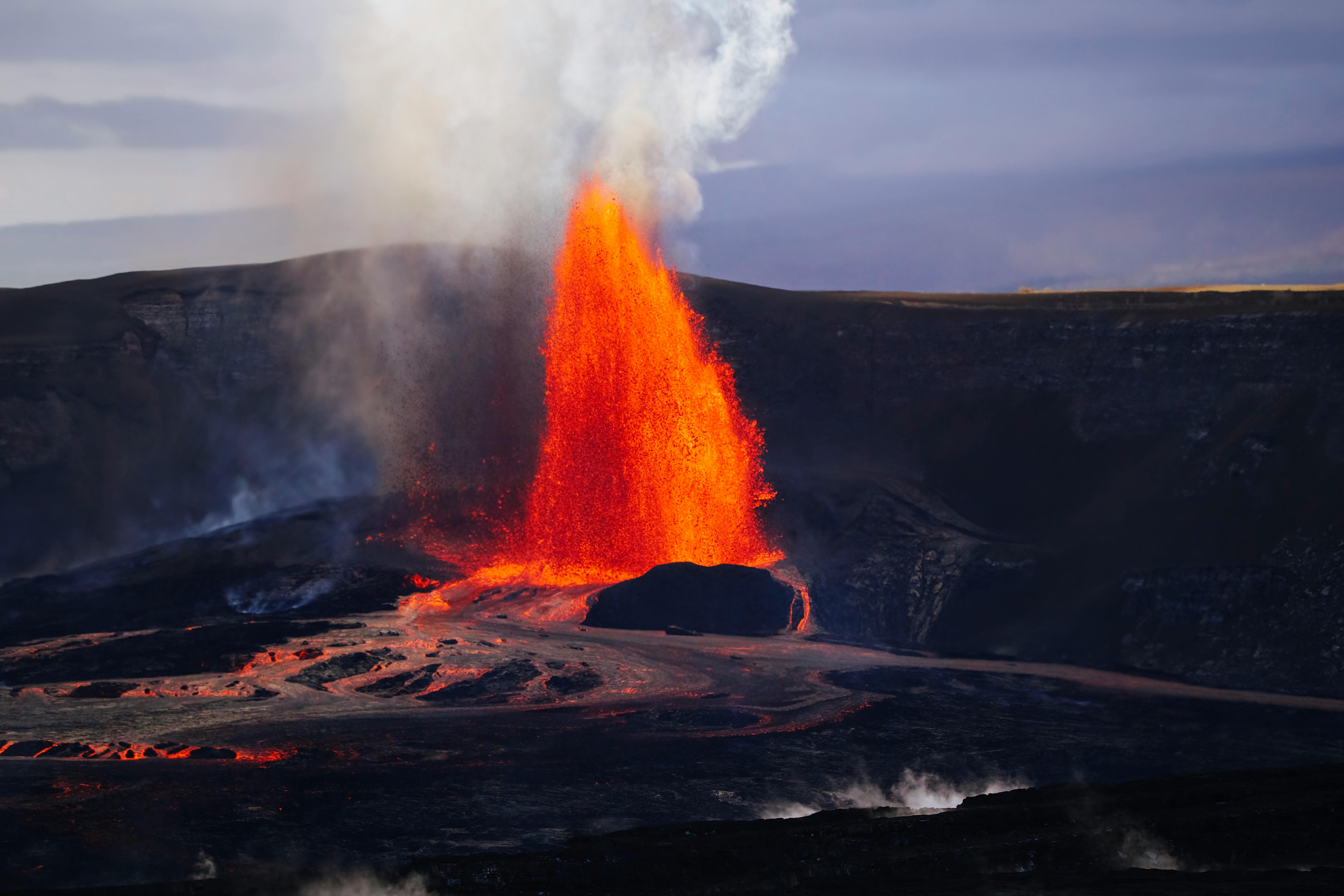
3. **Kīlauea, Hawaii: A Persistent Global Hotspot**Situated on the Island of Hawai’i, Kīlauea stands as a prime example of a “very high threat” volcano, recognized not only as the youngest on the island but also as “one of the world’s most active and the country’s most dangerous.” Its relentless geological activity has captivated scientists and observers for decades, making it a natural laboratory for studying ongoing volcanic processes. The sheer volume and consistency of its eruptions underscore its prominent position on the national watchlist.
Kīlauea’s eruptive history is remarkably extensive and prolonged, characterized by “dozens of times since 1952” that it has released its fiery contents. This frequent activity escalated into a period of “almost continuous activity between 1983 and 2018,” a span of 35 years during which the volcano was in a near-constant state of eruption. Such sustained output highlights its profound internal dynamism and the immense geological forces at play beneath the Hawaiian landscape.
A defining feature of Kīlauea’s recent past was the sustained presence of a lava pond at its summit. For “ten full years between 2008 and 2018,” the Halema’uma’u crater hosted this molten pool, which served as a visible manifestation of the volcano’s internal plumbing system. This persistent lava pond was also notable for emitting “an intense gas plume,” a clear indicator of the constant release of volcanic gases into the atmosphere, which adds another layer of hazard.
Following a period of significant changes in its eruptive style, the lava pond once again reformed in the Halema’uma’u crater after a subsequent eruption. This newer episode of activity commenced in “December 2020 and lasted until May 2021,” demonstrating the volcano’s inherent capacity for renewal and the continuation of its established patterns, even after intervals of relative quiet.
Critically, the geological processes driving Kīlauea show no signs of abating. The reformed lava pond in Halema’uma’u crater did not signify a definitive end to its activity. Instead, it “fed yet another eruption which began in September 2021 and is still persisting today,” as reported in the context. This ongoing eruption reinforces Kīlauea’s status as a continuously evolving and highly active volcanic system, demanding constant scientific observation and public awareness due to its formidable and persistent threat.
4. **The Nature of Kīlauea’s Eruptive Activity**Kīlauea’s designation as a shield volcano is intrinsically linked to the characteristic nature of its eruptions, which, while not explicitly detailed in the context, typically involve effusive lava flows that build up broad, gently sloping cones. The sustained period of “almost continuous activity between 1983 and 2018” speaks volumes about the constant magma supply feeding this system, allowing for prolonged periods of lava emission rather than explosive, episodic blasts. This long-term activity shapes the landscape of the Island of Hawai’i significantly.
The frequency of Kīlauea’s eruptions, noted as “dozens of times since 1952,” further illustrates its highly active state. This constant geological unrest means that the volcano is not merely a static landform, but a living, breathing entity that consistently vents and reshapes its immediate environment. Such regular activity provides invaluable data for volcanologists, offering real-time insights into the complex processes that drive volcanic systems globally.
The presence of the “lava pond” at the summit for a full decade, from “2008 to 2018,” offers a direct window into the volcano’s internal dynamics. This exposed pool of molten rock not only served as a visual spectacle but also provided critical information about the volcano’s plumbing system and magma reservoir. The accompanying “intense gas plume” was a continuous reminder of the volatile chemicals being released from deep within the Earth, affecting local air quality and broader atmospheric conditions.
The recent sequence of eruptions underscores Kīlauea’s dynamic and adaptive nature. The eruption from “December 2020 to May 2021,” which led to the reformation of the lava pond, demonstrated the volcano’s capacity to adjust its eruptive behavior. This was swiftly followed by another, more persistent eruption that “began in September 2021 and is still persisting today.” This continuous cycle of activity highlights the enduring pressure within Kīlauea’s magmatic system and its readiness to erupt.
For residents and scientists alike, understanding the unique, ongoing nature of Kīlauea’s activity is paramount. Its status as the country’s “most dangerous” volcano is not solely due to its potential for destruction, but also its relentless, ever-present activity, which demands a high level of preparedness and a sophisticated network of monitoring equipment to track every tremor and gas emission.

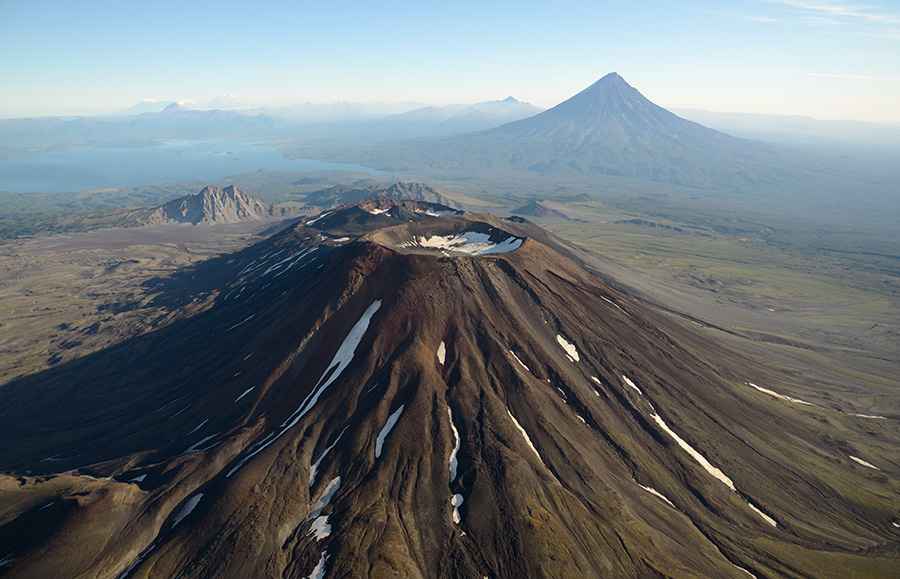
5. **Mount St. Helens, Washington: A History of Oscillating Activity**Moving from the Pacific’s volcanic hot zone to the continental United States, Mount St. Helens in Washington State emerges as another critical entity on the “very high threat” watchlist. It is distinguished as “the most active volcano in the Cascade Range,” a significant chain of peaks known for their eruptive potential. Its geographical prominence in the Pacific Northwest makes its behavior a focal point for geological observation and regional preparedness efforts.
Mount St. Helens’ history is marked by a distinctive pattern of geological behavior, having “oscillated between violent and dormant periods throughout its history.” This cyclical nature of intense eruptions followed by quieter phases is characteristic of many stratovolcanoes and presents a unique challenge for forecasting. Periods of dormancy can often precede more explosive events, as pressure builds over time beneath the surface, making its historical record particularly crucial for assessment.
The volcano’s geological context is further defined by its inclusion as “part of the Ring of Fire.” This notorious region, encompassing a vast stretch of “volcanic and seismic activity that spans from the West Coast of South America all the way to Alaska and the Aleutian Islands,” places Mount St. Helens within a global network of tectonically active areas. Its connection to this larger system underscores the deep-seated forces that fuel its dynamism and contribute to its significant hazard potential.
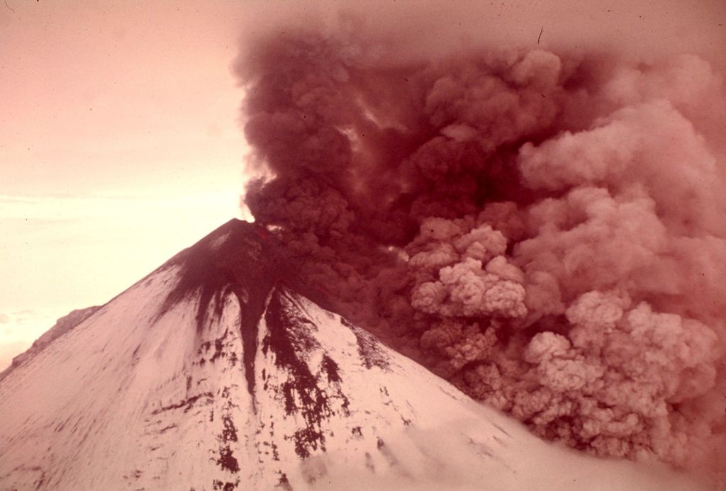
One of the most indelible dates in Mount St. Helens’ modern history is May 18, 1980. On this day, “a particul” event occurred, which signaled a dramatic reawakening of the volcano and reshaped the landscape surrounding it. While the specific details of this event are only partially introduced in the provided context, the date itself remains a powerful reminder of the volcano’s immense destructive power and its capacity for sudden and profound transformation of its environment.
Given its status as the “most active volcano in the Cascade Range” and its position within the volatile Ring of Fire, Mount St. Helens necessitates ongoing and rigorous monitoring. Its history of “oscillating between violent and dormant periods” dictates that even during seemingly quiet phases, scientists must maintain a high degree of vigilance. Understanding the subtle shifts in its seismic activity, gas emissions, and ground deformation is essential to anticipate and respond to its next reawakening, ensuring the safety of communities throughout the Pacific Northwest.
6. **The Global Ring of Fire Phenomenon: Earth’s Fiery Edge**The Earth’s surface is a dynamic tapestry, and nowhere is this more evident than along the notorious “Ring of Fire.” This vast, horseshoe-shaped belt, spanning from the West Coast of South America all the way to Alaska and the Aleutian Islands, is a nexus of intense “volcanic and seismic activity.” It represents a continuous string of volcanoes and oceanic trenches where major tectonic plates converge, setting the stage for some of the planet’s most dramatic geological events.
Mount St. Helens, a prominent feature in the Cascade Range, is unequivocally recognized as “part of the Ring of Fire,” underscoring its deep connection to this global network. This inclusion is not merely a geographical label; it signifies that the forces fueling its eruptions are intrinsically linked to the larger tectonic dynamics that shape this entire region. The “deep-seated forces” contributing to its significant hazard potential are shared across this immense geological arc.
Understanding the Ring of Fire is crucial for comprehending the widespread distribution of “very high threat” volcanoes around the globe, including those within the United States. Its existence means that volcanic hazards are not isolated occurrences but rather manifestations of a connected, planetary system. The seismic and volcanic tremors along this belt are constant reminders of the immense pressures and transformations occurring beneath our feet, influencing a significant portion of the world’s geology.
The dynamism of this region makes it a focal point for geological observation and preparedness efforts worldwide. Each active volcano within the Ring of Fire, from those in the Americas to those in Asia and Oceania, contributes to a collective understanding of Earth’s internal workings. The interlinked nature of these systems necessitates a global approach to monitoring and research, as activity in one area can provide insights into potential events in another.

7. **The Scientific Imperative: Eruption Inevitability**For many of the geological giants scattered across the globe, particularly those categorized as “very high threat,” scientists operate under a stark, fundamental reality: “it is not a question of if an eruption will occur, but rather when.” This profound understanding acknowledges the inherent, unstoppable forces at play within Earth’s mantle and crust. It moves beyond speculation to a principled acceptance of geological destiny for these volatile systems.
This scientific imperative is born from the “inherent unpredictability” of volcanoes, coupled with their immense “destructive potential.” While the precise timing of an eruption often remains elusive, the geological record and current observations of many active or dormant volcanoes strongly indicate future activity. This acceptance of inevitability drives continuous efforts to understand and predict, even as the exact moment remains a mystery.
Such a perspective places a “perpetual emphasis on vigilance and scientific inquiry.” It means that even when a volcano appears quiet, its internal processes are under constant scrutiny. Scientists meticulously collect data on seismic activity, gas emissions, and ground deformation, all serving as potential precursors to an impending event, helping to refine the “when, not if” equation with increasing precision.
This fundamental understanding underpins the extensive “continuous monitoring and analytical efforts” of agencies like the U.S. Geological Survey. It ensures that “very high threat” volcanoes remain under intense scrutiny, even during “quiescent periods.” The observation of “geological indicators constantly” is not just an academic exercise; it is a vital practice for safeguarding communities living in proximity to these formidable natural forces.
8. **Societal Impact and Mitigation of Volcanic Hazards**The immense power of volcanoes translates into “far-reaching consequences” for human society, extending far beyond the immediate vicinity of an eruption. These geological events are capable of profoundly disrupting daily life, infrastructure, and economies, necessitating robust strategies for impact mitigation and preparedness. The threats posed by these natural phenomena demand a comprehensive societal response.
The “very high threat” designation for certain volcanoes is largely driven by their capacity to unleash a formidable array of materials. “Lava, debris, and noxious gas spewing giants” each present “distinct hazards.” Lava flows incinerate everything in their path, while volcanic debris, including ash and larger projectiles, can travel significant distances, thereby “impacting air travel, infrastructure, and agricultural lands.” The broad devastation can halt commerce, damage vital utilities, and render vast areas uninhabitable.
Beyond direct physical destruction, the “release of noxious gas” presents a “silent, yet equally deadly, threat,” capable of “contaminating breathable air over wide areas.” This invisible danger can cause widespread health issues and necessitate large-scale evacuations, further compounding the societal disruption. The long-term environmental and health impacts from such emissions can linger for years, affecting ecosystems and human populations.
The “necessity of such a national assessment” as conducted by the USGS is self-evident in a country where volcanic activity, even if localized, can have such profound implications. The insights gleaned from this authoritative approach are “vital for informing public policy and disaster preparedness.” By clearly delineating top-tier threats, agencies can “allocate resources effectively, develop tailored evacuation plans, and educate communities” residing in the shadow of these geological formations.
Ultimately, understanding these formidable natural phenomena and proactively preparing for their impacts is not merely an academic pursuit; it is a “vital endeavor for public safety and informed preparedness.” The commitment to “mitigating the impacts of volcanic events before they escalate into larger crises” is paramount for “safeguarding lives and infrastructure” against Earth’s relentless geological forces.
9. **The Indispensable Role of Geological Monitoring**In the face of nature’s formidable volcanic power and its inherent unpredictability, “continuous monitoring and analytical efforts” stand as the primary line of defense. This unwavering vigilance is crucial for tracking the dynamic geological systems that underpin volcanoes, allowing scientists to discern subtle shifts that may herald an impending eruption. It transforms dormant giants from passive threats into subjects of active, systematic observation.
Scientists diligently observe “geological indicators constantly” for any signs of an “impending reawakening,” even during periods when a volcano appears quiet. These indicators can include changes in seismic activity, ground deformation measured by GPS or satellite imagery, and alterations in the composition or volume of gas emissions. Each piece of data contributes to a complex puzzle, providing insights into the pressure building beneath the surface.
The detailed observation of systems like Kīlauea demonstrates the critical importance of a “sophisticated network of monitoring equipment to track every tremor and gas emission.” Such networks provide real-time data, allowing volcanologists to interpret ongoing processes and detect patterns that could signal increased danger. This granular level of detail is essential for issuing timely warnings and informing preparedness measures.
This “proactive stance” adopted by national assessments ensures that “scientific understanding evolves with the volcanoes themselves,” providing the “most current information possible.” The constant influx of data allows for the refinement of predictive models and a deeper comprehension of individual volcanic behaviors. It’s an ongoing dialogue between human intellect and Earth’s powerful forces, driven by the need to protect communities.
Ultimately, the rigorous scrutiny demanded by “very high threat” volcanoes requires a sustained commitment to these monitoring efforts. It allows for prompt responses and informs crucial decisions that can mean the difference between life and widespread catastrophe. The persistent, ever-present activity of the country’s “most dangerous” volcanoes necessitates this continuous observation and a high level of preparedness from all stakeholders.
Read more about: Unveiling the Mediterranean: A Comprehensive Journey Through its History, Geography, and Enduring Significance

10. **Unseen Threats: The Dangers of Volcanic Emissions**While lava flows and explosive debris represent visible and immediate dangers, the “release of noxious gas” from volcanoes poses a “silent, yet equally deadly, threat.” These invisible emissions can travel significant distances, silently impacting environments and human health far from the volcanic vent itself. Their insidious nature demands a distinct focus in hazard assessment and mitigation strategies.
The historical activity of volcanoes such as Kīlauea provides a clear illustration of this danger. For “ten full years between 2008 and 2018,” its summit lava pond emitted “an intense gas plume,” a palpable manifestation of these volatile releases. Such plumes are not merely atmospheric curiosities; they are laden with a cocktail of chemicals that can have severe environmental and health ramifications for nearby populations.
These “volatile chemicals being released from deep within the Earth” include sulfur dioxide, carbon dioxide, hydrogen sulfide, and other hazardous compounds. When released into the atmosphere, they can affect “local air quality and broader atmospheric conditions,” leading to respiratory illnesses, acid rain, and even contributing to regional climate shifts. The sustained presence of these gases necessitates ongoing monitoring and public health advisories.
Critically, the capacity of these “noxious gases” to contaminate “breathable air over wide areas” makes them a far-reaching hazard. Wind patterns can carry these plumes for hundreds of miles, affecting communities seemingly safe from lava flows or ashfall. This widespread dispersal potential underscores the complex and multi-faceted nature of volcanic threats, extending the zone of potential impact well beyond immediate proximity to the crater.
As our journey through America’s most hazardous volcanoes concludes, it becomes undeniably clear that these geological giants command our unwavering respect and vigilant attention. From the global forces shaping the Ring of Fire to the meticulous daily work of geological monitoring, every facet of volcanic activity underscores the imperative for scientific understanding and robust preparedness. The Earth’s relentless geological forces remind us that while the ‘if’ of an eruption may be certain, the ‘when’ demands continuous vigilance and informed action to safeguard lives and landscapes against their awe-inspiring power.


